Features Overview

Hint

You can run this notebook in a live session with Binder.

Features Overview#

This overview demonstrates the basic capabilities of eodag in a simple worflow, whose steps are introduced in more details in the following pages.

The workflow consists of the following steps:

  1. Configure: eodag is configured to use the provider cop_dataspace (registering to cop_dataspace is required to download the products, see how to register to a provider)

  2. Search: Sentinel 2 Level-1C products (i.e. images) are searched for over an area in France in March 2021.

  3. Crunch: Two dedicated filters - that we call crunchers - provided by eodag are used to select products with a cloud cover less than 30% and covering the city of Toulouse (France).

  4. Serialize: Save the filtered products as a GeoJSON file.

  5. Download: The products are downloaded.

  6. Post-process: eodag-cube is an external package that is used to access a product’s data, it is going to be used to calculate the NDVI of a product.

Configure#

Let us first create a workspace directory to save products downloaded during this workflow.

[10]:
import os

workspace = 'eodag_workspace_overview'
if not os.path.isdir(workspace):
    os.mkdir(workspace)

Now we will configure eodag to be able to download using cop_dataspace. For that we need to fill our credentials:

  • in the user configuration file ~/.config/eodag/eodag.yml:

cop_dataspace:
    priority: # Lower value means lower priority (Default: 1)
    search:  # Search parameters configuration
    download:
        extract:  # whether to extract the downloaded products (true or false, Default: true).
        output_dir: # where to store downloaded products.
        dl_url_params:  # additional parameters to pass over to the download url as an url parameter
        delete_archive: # whether to delete the downloaded archives (true or false, Default: true).
    auth:
        credentials:
            username: PLEASE_CHANGE_ME
            password: PLEASE_CHANGE_ME
  • or using environment variables: (we also set output_dir, the directory where to store downloaded products)

[11]:
# os.environ["EODAG__COP_DATASPACE__AUTH__CREDENTIALS__USERNAME"] = "PLEASE_CHANGE_ME"
# os.environ["EODAG__COP_DATASPACE__AUTH__CREDENTIALS__PASSWORD"] = "PLEASE_CHANGE_ME"
os.environ["EODAG__COP_DATASPACE__DOWNLOAD__OUTPUT_DIR"] = os.path.abspath(workspace)

Logging is then activated with the setup_logging() method. It’s a useful way to see what eodag does under the hood, e.g. requesting the provider, adapting the response. It’s also useful to detect when things go wrong, and, if relevant, create an issue on GitHub with the log messages.

[6]:
from eodag import setup_logging
setup_logging(2)  # 3 for even more information

The next object to import, and this is certainly one of the most important objects provided by eodag, is the EODataAccessGateway class. The creation of a single instance of this class is enough in a workflow, it is going to take care of configuring the providers, exposing the products configured off-the-shelf by eodag, and many more things.

[23]:
from eodag import EODataAccessGateway
dag = EODataAccessGateway()
2026-03-26 18:08:49,052 eodag.provider                   [INFO    ] Loading user configuration from: /home/sbrunato/.config/eodag/eodag.yml
2026-03-26 18:08:49,076 eodag.core                       [INFO    ] Locations configuration loaded from /home/sbrunato/.config/eodag/locations.yml

eodag stores an internal catalog of products it makes easily accessible. Sentinel 2 Level-1C products are designated with the identifier S2_MSI_L1C. It’s possible to check that it’s made available by cop_dataspace with the method list_collections() which returns a list of Collection instances, each one of them containing general metadata (eodag’s collection id, platform, sensor type, etc.).

[8]:
dag.list_collections("cop_dataspace")
[8]:
CollectionsList (63)
0  Collection("S1_AUX_GNSSRD")
id: 'S1_AUX_GNSSRD',
title: 'SENTINEL1 Auxiliary Product',
description: 'The Auxiliary (AUX) product contains the precise orbit ephemerides and the GNSS-Raw Data (GNSSRD) data. The precise orbit ephemerides are provided as a text file in the format of the International GNSS Service (IGS). The GNSS-Raw Data (GNSSRD) data is provided as a binary file in a specific format. SAFE formatted product, see https://sentinel.esa.int/web/sentinel/user-guides/sentinel-1-sar/data-formats/safe-specification ',
extent: { 'spatial': { 'bbox': [[-180.0 , -90.0 , 180.0 , 90.0 ] ] } , 'temporal': { 'interval': [[2014-04-06 00:00:00+00:00 , None ] ] } },
keywords: ['SAR' , 'SENTINEL' , 'SENTINEL1' , 'S1' , 'S1A' , 'S1B' , 'S1C' , 'AUX' , 'GNSSRD' , 'SAFE' ],
license: 'other',
providers: [{ 'name': 'European Space Agency (ESA)' , 'roles': ['producer' , 'processor' , 'licensor' ] , 'url': 'https://earth.esa.int' } ],
constellation: 'SENTINEL1',
instruments: ['SAR' ],
platform: 'S1A,S1B,S1C',
processing:level: 'AUX',
eodag:sensor_type: 'RADAR',
1  Collection("S1_AUX_MOEORB")
id: 'S1_AUX_MOEORB',
title: 'SENTINEL1 Auxiliary Product',
description: 'The Auxiliary (AUX) product contains the precise orbit ephemerides and the GNSS-Raw Data (GNSSRD) data. The precise orbit ephemerides are provided as a text file in the format of the European Space Operations Centre (ESOC). The GNSS-Raw Data (GNSSRD) data is provided as a binary file in a specific format. SAFE formatted product, see https://sentinel.esa.int/web/sentinel/user-guides/sentinel-1-sar/data-formats/safe-specification ',
extent: { 'spatial': { 'bbox': [[-180.0 , -90.0 , 180.0 , 90.0 ] ] } , 'temporal': { 'interval': [[2014-04-06 00:00:00+00:00 , None ] ] } },
keywords: ['SAR' , 'SENTINEL' , 'SENTINEL1' , 'S1' , 'S1A' , 'S1B' , 'S1C' , 'AUX' , 'MOEORB' , 'SAFE' ],
license: 'other',
providers: [{ 'name': 'European Space Agency (ESA)' , 'roles': ['producer' , 'processor' , 'licensor' ] , 'url': 'https://earth.esa.int' } ],
constellation: 'SENTINEL1',
instruments: ['SAR' ],
platform: 'S1A,S1B,S1C',
processing:level: 'AUX',
eodag:sensor_type: 'RADAR',
2  Collection("S1_AUX_POEORB")
id: 'S1_AUX_POEORB',
title: 'SENTINEL1 Auxiliary Product',
description: 'The Auxiliary (AUX) product contains the precise orbit ephemerides and the GNSS-Raw Data (GNSSRD) data. The precise orbit ephemerides are provided as a text file in the format of the European Space Operations Centre (ESOC). The GNSS-Raw Data (GNSSRD) data is provided as a binary file in a specific format. SAFE formatted product, see https://sentinel.esa.int/web/sentinel/user-guides/sentinel-1-sar/data-formats/safe-specification ',
extent: { 'spatial': { 'bbox': [[-180.0 , -90.0 , 180.0 , 90.0 ] ] } , 'temporal': { 'interval': [[2014-04-06 00:00:00+00:00 , None ] ] } },
keywords: ['SAR' , 'SENTINEL' , 'SENTINEL1' , 'S1' , 'S1A' , 'S1B' , 'S1C' , 'AUX' , 'POEORB' , 'SAFE' ],
license: 'other',
providers: [{ 'name': 'European Space Agency (ESA)' , 'roles': ['producer' , 'processor' , 'licensor' ] , 'url': 'https://earth.esa.int' } ],
constellation: 'SENTINEL1',
instruments: ['SAR' ],
platform: 'S1A,S1B,S1C',
processing:level: 'AUX',
eodag:sensor_type: 'RADAR',
3  Collection("S1_AUX_PREORB")
id: 'S1_AUX_PREORB',
title: 'SENTINEL1 Auxiliary Product',
description: 'The Auxiliary (AUX) product contains the precise orbit ephemerides and the GNSS-Raw Data (GNSSRD) data. The precise orbit ephemerides are provided as a text file in the format of the European Space Operations Centre (ESOC). The GNSS-Raw Data (GNSSRD) data is provided as a binary file in a specific format. SAFE formatted product, see https://sentinel.esa.int/web/sentinel/user-guides/sentinel-1-sar/data-formats/safe-specification ',
extent: { 'spatial': { 'bbox': [[-180.0 , -90.0 , 180.0 , 90.0 ] ] } , 'temporal': { 'interval': [[2014-04-06 00:00:00+00:00 , None ] ] } },
keywords: ['SAR' , 'SENTINEL' , 'SENTINEL1' , 'S1' , 'S1A' , 'S1B' , 'S1C' , 'AUX' , 'PREORB' , 'SAFE' ],
license: 'other',
providers: [{ 'name': 'European Space Agency (ESA)' , 'roles': ['producer' , 'processor' , 'licensor' ] , 'url': 'https://earth.esa.int' } ],
constellation: 'SENTINEL1',
instruments: ['SAR' ],
platform: 'S1A,S1B,S1C',
processing:level: 'AUX',
eodag:sensor_type: 'RADAR',
4  Collection("S1_AUX_PROQUA")
id: 'S1_AUX_PROQUA',
title: 'SENTINEL1 Auxiliary Product',
description: 'The Auxiliary (AUX) product contains the precise orbit ephemerides and the GNSS-Raw Data (GNSSRD) data. The precise orbit ephemerides are provided as a text file in the format of the European Space Operations Centre (ESOC). The GNSS-Raw Data (GNSSRD) data is provided as a binary file in a specific format. SAFE formatted product, see https://sentinel.esa.int/web/sentinel/user-guides/sentinel-1-sar/data-formats/safe-specification ',
extent: { 'spatial': { 'bbox': [[-180.0 , -90.0 , 180.0 , 90.0 ] ] } , 'temporal': { 'interval': [[2014-04-06 00:00:00+00:00 , None ] ] } },
keywords: ['SAR' , 'SENTINEL' , 'SENTINEL1' , 'S1' , 'S1A' , 'S1B' , 'S1C' , 'AUX' , 'PROQUA' , 'SAFE' ],
license: 'other',
providers: [{ 'name': 'European Space Agency (ESA)' , 'roles': ['producer' , 'processor' , 'licensor' ] , 'url': 'https://earth.esa.int' } ],
constellation: 'SENTINEL1',
instruments: ['SAR' ],
platform: 'S1A,S1B,S1C',
processing:level: 'AUX',
eodag:sensor_type: 'RADAR',
5  Collection("S1_AUX_RESORB")
id: 'S1_AUX_RESORB',
title: 'SENTINEL1 Auxiliary Product',
description: 'The Auxiliary (AUX) product contains the precise orbit ephemerides and the GNSS-Raw Data (GNSSRD) data. The precise orbit ephemerides are provided as a text file in the format of the European Space Operations Centre (ESOC). The GNSS-Raw Data (GNSSRD) data is provided as a binary file in a specific format. SAFE formatted product, see https://sentinel.esa.int/web/sentinel/user-guides/sentinel-1-sar/data-formats/safe-specification ',
extent: { 'spatial': { 'bbox': [[-180.0 , -90.0 , 180.0 , 90.0 ] ] } , 'temporal': { 'interval': [[2014-04-06 00:00:00+00:00 , None ] ] } },
keywords: ['SAR' , 'SENTINEL' , 'SENTINEL1' , 'S1' , 'S1A' , 'S1B' , 'S1C' , 'AUX' , 'RESORB' , 'SAFE' ],
license: 'other',
providers: [{ 'name': 'European Space Agency (ESA)' , 'roles': ['producer' , 'processor' , 'licensor' ] , 'url': 'https://earth.esa.int' } ],
constellation: 'SENTINEL1',
instruments: ['SAR' ],
platform: 'S1A,S1B,S1C',
processing:level: 'AUX',
eodag:sensor_type: 'RADAR',
6  Collection("S1_SAR_GRD")
id: 'S1_SAR_GRD',
title: 'SENTINEL1 Level-1 Ground Range Detected',
description: 'Level-1 Ground Range Detected (GRD) products consist of focused SAR data that has been detected, multi-looked and projected to ground range using an Earth ellipsoid model. Phase information is lost. The resulting product has approximately square spatial resolution pixels and square pixel spacing with reduced speckle at the cost of worse spatial resolution. GRD products can be in one of three resolutions: | Full Resolution (FR), High Resolution (HR), Medium Resolution (MR). The resolution is dependent upon the amount of multi-looking performed. Level-1 GRD products are available in MR and HR for IW and EW modes, MR for WV mode and MR, HR and FR for SM mode. SAFE formatted product, see https://sentinel.esa.int/web/sentinel/user-guides/sentinel-1-sar/data-formats/safe-specification ',
extent: { 'spatial': { 'bbox': [[-180.0 , -90.0 , 180.0 , 90.0 ] ] } , 'temporal': { 'interval': [[2014-04-03 00:00:00+00:00 , None ] ] } },
keywords: ['SAR' , 'SENTINEL' , 'SENTINEL1' , 'S1' , 'S1A' , 'S1B' , 'S1C' , 'L1' , 'GRD' , 'SAFE' ],
license: 'other',
providers: [{ 'name': 'European Space Agency (ESA)' , 'roles': ['producer' , 'processor' , 'licensor' ] , 'url': 'https://earth.esa.int' } ],
constellation: 'SENTINEL1',
instruments: ['SAR' ],
platform: 'S1A,S1B,S1C',
processing:level: 'L1',
eodag:sensor_type: 'RADAR',
7  Collection("S1_SAR_GRD_COG")
id: 'S1_SAR_GRD_COG',
title: 'SENTINEL1 Level-1 Ground Range Detected',
description: 'Level-1 Ground Range Detected (GRD) products consist of focused SAR data that has been detected, multi-looked and projected to ground range using an Earth ellipsoid model. Phase information is lost. The resulting product has approximately square spatial resolution pixels and square pixel spacing with reduced speckle at the cost of worse spatial resolution. GRD products can be in one of three resolutions: | Full Resolution (FR), High Resolution (HR), Medium Resolution (MR). The resolution is dependent upon the amount of multi-looking performed. Level-1 GRD products are available in MR and HR for IW and EW modes, MR for WV mode and MR, HR and FR for SM mode. Product containing Cloud Optimized GeoTIFF images, without SAFE formatting. https://sentinel.esa.int/web/sentinel/user-guides/sentinel-1-sar/data-formats/safe-specification ',
extent: { 'spatial': { 'bbox': [[-180.0 , -90.0 , 180.0 , 90.0 ] ] } , 'temporal': { 'interval': [[2014-04-03 00:00:00+00:00 , None ] ] } },
keywords: ['SAR' , 'SENTINEL' , 'SENTINEL1' , 'S1' , 'S1A' , 'S1B' , 'S1C' , 'L1' , 'GRD' , 'COG' ],
license: 'other',
providers: [{ 'name': 'European Space Agency (ESA)' , 'roles': ['producer' , 'processor' , 'licensor' ] , 'url': 'https://earth.esa.int' } ],
constellation: 'SENTINEL1',
instruments: ['SAR' ],
platform: 'S1A,S1B,S1C',
processing:level: 'L1',
eodag:sensor_type: 'RADAR',
8  Collection("S1_SAR_L3_DH_MCM")
id: 'S1_SAR_L3_DH_MCM',
title: 'SENTINEL1 Level-3 DH MCM',
description: 'Level-3 DH (Dual polarization High Resolution) products are terrain corrected (geocoded) products in map geometry, projected using the Range-Doppler model and resampled using nearest neighbor method. The pixel spacing is approximately 10 m x 10 m. The product is available in dual polarization (HH+HV or VV+VH). The product is provided in GeoTIFF format. Product containing Cloud Optimized GeoTIFF images, without SAFE formatting. https://sentinel.esa.int/web/sentinel/user-guides/sentinel-1-sar/data-formats/safe-specification ',
extent: { 'spatial': { 'bbox': [[-180.0 , -90.0 , 180.0 , 90.0 ] ] } , 'temporal': { 'interval': [[2023-01-01 00:00:00+00:00 , None ] ] } },
keywords: ['SAR' , 'SENTINEL' , 'SENTINEL1' , 'S1' , 'S1A' , 'S1B' , 'S1C' , 'L3' , 'DH' , 'MCM' , 'COG' ],
license: 'other',
providers: [{ 'name': 'European Space Agency (ESA)' , 'roles': ['producer' , 'processor' , 'licensor' ] , 'url': 'https://earth.esa.int' } ],
constellation: 'SENTINEL1',
instruments: ['SAR' ],
platform: 'S1A,S1B,S1C',
processing:level: 'L3',
eodag:sensor_type: 'RADAR',
9  Collection("S1_SAR_L3_IW_MCM")
id: 'S1_SAR_L3_IW_MCM',
title: 'SENTINEL1 Level-3 IW MCM',
description: 'Level-3 IW (Interferometric Wide Swath) products are terrain corrected (geocoded) products in map geometry, projected using the Range-Doppler model and resampled using nearest neighbor method. The pixel spacing is approximately 10 m x 10 m. The product is available in two polarizations: Single (HH or VV) and Dual (HH+HV or VV+VH). The product is provided in GeoTIFF format. Product containing Cloud Optimized GeoTIFF images, without SAFE formatting. https://sentinel.esa.int/web/sentinel/user-guides/sentinel-1-sar/data-formats/safe-specification ',
extent: { 'spatial': { 'bbox': [[-180.0 , -90.0 , 180.0 , 90.0 ] ] } , 'temporal': { 'interval': [[2023-01-01 00:00:00+00:00 , None ] ] } },
keywords: ['SAR' , 'SENTINEL' , 'SENTINEL1' , 'S1' , 'S1A' , 'S1B' , 'S1C' , 'L3' , 'IW' , 'MCM' , 'COG' ],
license: 'other',
providers: [{ 'name': 'European Space Agency (ESA)' , 'roles': ['producer' , 'processor' , 'licensor' ] , 'url': 'https://earth.esa.int' } ],
constellation: 'SENTINEL1',
instruments: ['SAR' ],
platform: 'S1A,S1B,S1C',
processing:level: 'L3',
eodag:sensor_type: 'RADAR',
10  Collection("S1_SAR_OCN")
id: 'S1_SAR_OCN',
title: 'SENTINEL1 Level-2 OCN',
description: 'Level-2 OCN products include components for Ocean Swell spectra (OSW) providing continuity with ERS and ASAR WV and two new components: Ocean Wind Fields (OWI) and Surface Radial Velocities (RVL). The OSW is a two-dimensional ocean surface swell spectrum and includes an estimate of the wind speed and direction per swell spectrum. The OSW is generated from Stripmap and Wave modes only. For Stripmap mode, there are multiple spectra derived from internally generated Level-1 SLC images. For Wave mode, there is one spectrum per vignette. The OWI is a ground range gridded estimate of the surface wind speed and direction at 10 m above the surface derived from internally generated Level-1 GRD images of SM, IW or EW modes. The RVL is a ground range gridded difference between the measured Level-2 Doppler grid and the Level-1 calculated geometrical Doppler. SAFE formatted product, see https://sentinel.esa.int/web/sentinel/user-guides/sentinel-1-sar/data-formats/safe-specification ',
extent: { 'spatial': { 'bbox': [[-180.0 , -90.0 , 180.0 , 90.0 ] ] } , 'temporal': { 'interval': [[2014-04-03 00:00:00+00:00 , None ] ] } },
keywords: ['SAR' , 'SENTINEL' , 'SENTINEL1' , 'S1' , 'S1A' , 'S1B' , 'S1C' , 'L2' , 'OCN' , 'SAFE' ],
license: 'other',
providers: [{ 'name': 'European Space Agency (ESA)' , 'roles': ['producer' , 'processor' , 'licensor' ] , 'url': 'https://earth.esa.int' } ],
constellation: 'SENTINEL1',
instruments: ['SAR' ],
platform: 'S1A,S1B,S1C',
processing:level: 'L2',
eodag:sensor_type: 'RADAR',
11  Collection("S1_SAR_RAW")
id: 'S1_SAR_RAW',
title: 'SENTINEL1 SAR Level-0',
description: 'The SAR Level-0 products consist of the sequence of Flexible Dynamic Block Adaptive Quantization (FDBAQ) compressed unfocused SAR raw data. For the data to be usable, it will need to be decompressed and processed using a SAR processor. SAFE formatted product, see https://sentinel.esa.int/web/sentinel/user-guides/sentinel-1-sar/data-formats/safe-specification ',
extent: { 'spatial': { 'bbox': [[-180.0 , -90.0 , 180.0 , 90.0 ] ] } , 'temporal': { 'interval': [[2014-04-03 00:00:00+00:00 , None ] ] } },
keywords: ['SAR' , 'SENTINEL' , 'SENTINEL1' , 'S1' , 'S1A' , 'S1B' , 'S1C' , 'L0' , 'RAW' , 'SAFE' ],
license: 'other',
providers: [{ 'name': 'European Space Agency (ESA)' , 'roles': ['producer' , 'processor' , 'licensor' ] , 'url': 'https://earth.esa.int' } ],
constellation: 'SENTINEL1',
instruments: ['SAR' ],
platform: 'S1A,S1B,S1C',
processing:level: 'L0',
eodag:sensor_type: 'RADAR',
12  Collection("S1_SAR_SLC")
id: 'S1_SAR_SLC',
title: 'SENTINEL1 Level-1 Single Look Complex',
description: 'Level-1 Single Look Complex (SLC) products consist of focused SAR data geo-referenced using orbit and attitude data from the satellite and provided in zero-Doppler slant-range geometry. The products include a single look in each dimension using the full transmit signal bandwidth and consist of complex samples preserving the phase information. SAFE formatted product, see https://sentinel.esa.int/web/sentinel/user-guides/sentinel-1-sar/data-formats/safe-specification ',
extent: { 'spatial': { 'bbox': [[-180.0 , -90.0 , 180.0 , 90.0 ] ] } , 'temporal': { 'interval': [[2014-04-03 00:00:00+00:00 , None ] ] } },
keywords: ['SAR' , 'SENTINEL' , 'SENTINEL1' , 'S1' , 'S1A' , 'S1B' , 'S1C' , 'L1' , 'SLC' , 'SAFE' ],
license: 'other',
providers: [{ 'name': 'European Space Agency (ESA)' , 'roles': ['producer' , 'processor' , 'licensor' ] , 'url': 'https://earth.esa.int' } ],
constellation: 'SENTINEL1',
instruments: ['SAR' ],
platform: 'S1A,S1B,S1C',
processing:level: 'L1',
eodag:sensor_type: 'RADAR',
13  Collection("S2_MSI_L1C")
id: 'S2_MSI_L1C',
title: 'SENTINEL2 Level-1C',
description: 'The Level-1C product is composed of 100x100 km2 tiles (ortho-images in UTM/WGS84 projection). It results from using a Digital Elevation Model (DEM) to project the image in cartographic geometry. Per-pixel radiometric measurements are provided in Top Of Atmosphere (TOA) reflectances along with the parameters to transform them into radiances. Level-1C products are resampled with a constant Ground Sampling Distance (GSD) of 10, 20 and 60 meters depending on the native resolution of the different spectral bands. In Level-1C products, pixel coordinates refer to the upper left corner of the pixel. Level-1C products will additionally include Cloud Masks and ECMWF data (total column of ozone, total column of water vapour and mean sea level pressure). SAFE formatted product, see https://sentinel.esa.int/web/sentinel/user-guides/sentinel-2-msi/data-formats ',
extent: { 'spatial': { 'bbox': [[-180.0 , -90.0 , 180.0 , 90.0 ] ] } , 'temporal': { 'interval': [[2015-06-23 00:00:00+00:00 , None ] ] } },
keywords: ['MSI' , 'SENTINEL' , 'SENTINEL2' , 'S2' , 'S2A' , 'S2B' , 'S2C' , 'L1' , 'L1C' , 'SAFE' ],
license: 'other',
providers: [{ 'name': 'European Space Agency (ESA)' , 'roles': ['producer' , 'processor' , 'licensor' ] , 'url': 'https://earth.esa.int' } ],
constellation: 'SENTINEL2',
instruments: ['MSI' ],
platform: 'S2A,S2B,S2C',
processing:level: 'L1',
eodag:sensor_type: 'OPTICAL',
14  Collection("S2_MSI_L2A")
id: 'S2_MSI_L2A',
title: 'SENTINEL2 Level-2A',
description: 'The Level-2A product provides Bottom Of Atmosphere (BOA) reflectance images derived from the associated Level-1C products. Each Level-2A product is composed of 100x100 km2 tiles in cartographic geometry (UTM/WGS84 projection). SAFE formatted product, see https://sentinel.esa.int/web/sentinel/user-guides/sentinel-2-msi/data-formats ',
extent: { 'spatial': { 'bbox': [[-180.0 , -90.0 , 180.0 , 90.0 ] ] } , 'temporal': { 'interval': [[2018-03-26 00:00:00+00:00 , None ] ] } },
keywords: ['MSI' , 'SENTINEL' , 'SENTINEL2' , 'S2' , 'S2A' , 'S2B' , 'S2C' , 'L2' , 'L2A' , 'SAFE' ],
license: 'other',
providers: [{ 'name': 'European Space Agency (ESA)' , 'roles': ['producer' , 'processor' , 'licensor' ] , 'url': 'https://earth.esa.int' } ],
constellation: 'SENTINEL2',
instruments: ['MSI' ],
platform: 'S2A,S2B,S2C',
processing:level: 'L2',
eodag:sensor_type: 'OPTICAL',
15  Collection("S3_EFR")
id: 'S3_EFR',
title: 'SENTINEL3 EFR',
description: 'OLCI (Ocean and Land Colour Instrument) Full resolution: 300m at nadir. Level 1 products are calibrated Top Of Atmosphere radiance values at OLCI 21 spectral bands. Radiances are computed from the instrument digital counts by applying geo-referencing, radiometric processing (non-linearity correction, smear correction, dark offset correction, absolute gain calibration adjusted for gain evolution with time), and stray-light correction for straylight effects in OLCI camera's spectrometer and ground imager. Additionally, spatial resampling of OLCI pixels to the 'ideal' instrument grid, initial pixel classification, and annotation at tie points with auxiliary meteorological data and acquisition geometry are provided. The radiance products are accompanied by error estimate products, however the error values are currently not available. - All Sentinel-3 NRT products are available at pick-up point in less than 3h. - All Sentinel-3 Non Time Critical (NTC) products are available at pick-up point in less than 30 days. Sentinel-3 is part of a series of Sentinel satellites, under the umbrella of the EU Copernicus programme. ',
extent: { 'spatial': { 'bbox': [[-180.0 , -90.0 , 180.0 , 90.0 ] ] } , 'temporal': { 'interval': [[2016-02-16 00:00:00+00:00 , None ] ] } },
keywords: ['OLCI' , 'SENTINEL' , 'SENTINEL3' , 'S3' , 'S3A' , 'S3B' , 'L1' , 'EFR' ],
license: 'other',
providers: [{ 'name': 'European Space Agency (ESA)' , 'roles': ['producer' , 'processor' , 'licensor' ] , 'url': 'https://earth.esa.int' } ],
constellation: 'SENTINEL3',
instruments: ['OLCI' ],
platform: 'S3A,S3B',
processing:level: 'L1',
eodag:sensor_type: 'OPTICAL',
16  Collection("S3_ERR")
id: 'S3_ERR',
title: 'SENTINEL3 ERR',
description: 'OLCI (Ocean and Land Colour Instrument) Reduced resolution: 1200m at nadir. All Sentinel-3 NRT products are available at pick-up point in less than 3h. Level 1 products are calibrated Top Of Atmosphere radiance values at OLCI 21 spectral bands. Radiances are computed from the instrument digital counts by applying geo-referencing, radiometric processing (non-linearity correction, smear correction, dark offset correction, absolute gain calibration adjusted for gain evolution with time), and stray-light correction for straylight effects in OLCI camera's spectrometer and ground imager. Additionally, spatial resampling of OLCI pixels to the 'ideal' instrument grid, initial pixel classification, and annotation at tie points with auxiliary meteorological data and acquisition geometry are provided. The radiance products are accompanied by error estimate products, however the error values are currently not available. - All Sentinel-3 NRT products are available at pick-up point in less than 3h - All Sentinel-3 Non Time Critical (NTC) products are available at pick-up point in less than 30 days Sentinel-3 is part of a series of Sentinel satellites, under the umbrella of the EU Copernicus programme. ',
extent: { 'spatial': { 'bbox': [[-180.0 , -90.0 , 180.0 , 90.0 ] ] } , 'temporal': { 'interval': [[2016-02-16 00:00:00+00:00 , None ] ] } },
keywords: ['OLCI' , 'SENTINEL' , 'SENTINEL3' , 'S3' , 'S3A' , 'S3B' , 'L1' , 'ERR' ],
license: 'other',
providers: [{ 'name': 'European Space Agency (ESA)' , 'roles': ['producer' , 'processor' , 'licensor' ] , 'url': 'https://earth.esa.int' } ],
constellation: 'SENTINEL3',
instruments: ['OLCI' ],
platform: 'S3A,S3B',
processing:level: 'L1',
eodag:sensor_type: 'OPTICAL',
17  Collection("S3_LAN")
id: 'S3_LAN',
title: 'SENTINEL3 SRAL Level-2 LAN',
description: 'LAN or SR_2_LAN___',
extent: { 'spatial': { 'bbox': [[-180.0 , -90.0 , 180.0 , 90.0 ] ] } , 'temporal': { 'interval': [[2016-02-16 00:00:00+00:00 , None ] ] } },
keywords: ['SRAL' , 'SENTINEL' , 'SENTINEL3' , 'S3' , 'S3A' , 'S3B' , 'L2' , 'LAN' ],
license: 'other',
providers: [{ 'name': 'European Space Agency (ESA)' , 'roles': ['producer' , 'processor' , 'licensor' ] , 'url': 'https://earth.esa.int' } ],
constellation: 'SENTINEL3',
instruments: ['SRAL' ],
platform: 'S3A,S3B',
processing:level: 'L2',
eodag:sensor_type: 'RADAR',
18  Collection("S3_LAN_HY")
id: 'S3_LAN_HY',
title: 'SENTINEL3 SRAL Level-2 LAN HYDRO',
description: 'Sentinel-3 STM payload includes two main instruments: the Sentinel-3 Radar ALtimeter (SRAL) and a MicroWave Radiometer (MWR). SRAL is providing continuous topography measurements of the Earth's surface. It is the first radar altimeter operating exclusively with delay-Doppler capabilities, which provides a significant improvement of the along-track resolution compared to conventional Low Resolution Mode (LRM) altimeters. This enhancement is highly valuable over continental and sea ice surfaces, considering their heterogeneous characteristics. ESA and the Sentinel-3 Mission Performance Cluster (MPC) have developed in 2021-2022 dedicated delay-Doppler and Level-2 processing chains for the generation of new Sentinel-3 STM LAND level-2 products over inland waters, sea-ice, and land ice areas. The main objective of these so-called “Thematic Products” is to address the specific needs of the user communities related to the three different Thematic surfaces. For Hydrology Thematic Products, the coverage includes all the continental surfaces, except the Antarctica ice sheet, and Greenland ice sheet interior. Over coastal zones the 50 km common area between Land and Marine products remains. Therefore, the Hydrology products cover up to 25 km over surfaces considered as Marine. ',
extent: { 'spatial': { 'bbox': [[-180.0 , -90.0 , 180.0 , 90.0 ] ] } , 'temporal': { 'interval': [[2016-02-16 00:00:00+00:00 , None ] ] } },
keywords: ['SRAL' , 'SENTINEL' , 'SENTINEL3' , 'S3' , 'S3A' , 'S3B' , 'L2' , 'LAN' , 'HYDROLOGY' ],
license: 'other',
providers: [{ 'name': 'European Space Agency (ESA)' , 'roles': ['producer' , 'processor' , 'licensor' ] , 'url': 'https://earth.esa.int' } ],
constellation: 'SENTINEL3',
instruments: ['SRAL' ],
platform: 'S3A,S3B',
processing:level: 'L2',
eodag:sensor_type: 'RADAR',
19  Collection("S3_LAN_LI")
id: 'S3_LAN_LI',
title: 'SENTINEL3 SRAL Level-2 LAN LAND ICE',
description: 'Sentinel-3 STM payload includes two main instruments: the Sentinel-3 Radar ALtimeter (SRAL) and a MicroWave Radiometer (MWR). SRAL is providing continuous topography measurements of the Earth's surface. It is the first radar altimeter operating exclusively with delay-Doppler capabilities, which provides a significant improvement of the along-track resolution compared to conventional Low Resolution Mode (LRM) altimeters. This enhancement is highly valuable over continental and sea ice surfaces, considering their heterogeneous characteristics. ESA and the Sentinel-3 Mission Performance Cluster (MPC) have developed in 2021-2022 dedicated delay-Doppler and Level-2 processing chains for the generation of new Sentinel-3 STM LAND level-2 products over inland waters, sea-ice, and land ice areas. The main objective of these so-called “Thematic Products” is to address the specific needs of the user communities related to the three different Thematic surfaces. Each Sentinel-3 STM Land Thematic Product has a dedicated geographical coverage, defined in a Thematic Mask. For Land Ice Thematic Products, the mask includes the Antarctica and Greenland ice sheets, along with glacier areas as defined in the Randolph Glacier Inventory (RGI) database. ',
extent: { 'spatial': { 'bbox': [[-180.0 , -90.0 , 180.0 , 90.0 ] ] } , 'temporal': { 'interval': [[2016-02-16 00:00:00+00:00 , None ] ] } },
keywords: ['SRAL' , 'SENTINEL' , 'SENTINEL3' , 'S3' , 'S3A' , 'S3B' , 'L2' , 'LAN' , 'LAND' , 'ICE' ],
license: 'other',
providers: [{ 'name': 'European Space Agency (ESA)' , 'roles': ['producer' , 'processor' , 'licensor' ] , 'url': 'https://earth.esa.int' } ],
constellation: 'SENTINEL3',
instruments: ['SRAL' ],
platform: 'S3A,S3B',
processing:level: 'L2',
eodag:sensor_type: 'RADAR',
20  Collection("S3_LAN_SI")
id: 'S3_LAN_SI',
title: 'SENTINEL3 SRAL Level-2 LAN SEA ICE',
description: 'Sentinel-3 STM payload includes two main instruments: the Sentinel-3 Radar ALtimeter (SRAL) and a MicroWave Radiometer (MWR). SRAL is providing continuous topography measurements of the Earth's surface. It is the first radar altimeter operating exclusively with delay-Doppler capabilities, which provides a significant improvement of the along-track resolution compared to conventional Low Resolution Mode (LRM) altimeters. This enhancement is highly valuable over continental and sea ice surfaces, considering their heterogeneous characteristics. ESA and the Sentinel-3 Mission Performance Cluster (MPC) have developed in 2021-2022 dedicated delay-Doppler and Level-2 processing chains for the generation of new Sentinel-3 STM LAND level-2 products over inland waters, sea-ice, and land ice areas. The main objective of these so-called “Thematic Products” is to address the specific needs of the user communities related to the three different Thematic surfaces. Each Sentinel-3 STM Land Thematic Product has a dedicated geographical coverage, defined in a Thematic Mask. For Sea Ice Thematic Products, the mask remains static, and the coverage was calculated by the Expert Support Laboratories (ESL) of the Sentinel-3 MPC, based on the maximum of sea ice extent given a NSIDC sea ice climatology. ',
extent: { 'spatial': { 'bbox': [[-180.0 , -90.0 , 180.0 , 90.0 ] ] } , 'temporal': { 'interval': [[2016-02-16 00:00:00+00:00 , None ] ] } },
keywords: ['SRAL' , 'SENTINEL' , 'SENTINEL3' , 'S3' , 'S3A' , 'S3B' , 'L2' , 'LAN' , 'SEA' , 'ICE' ],
license: 'other',
providers: [{ 'name': 'European Space Agency (ESA)' , 'roles': ['producer' , 'processor' , 'licensor' ] , 'url': 'https://earth.esa.int' } ],
constellation: 'SENTINEL3',
instruments: ['SRAL' ],
platform: 'S3A,S3B',
processing:level: 'L2',
eodag:sensor_type: 'RADAR',
21  Collection("S3_OLCI_L2LFR")
id: 'S3_OLCI_L2LFR',
title: 'SENTINEL3 OLCI Level-2 Land Full Resolution',
description: 'The OLCI Level-2 Land Full Resolution (OL_2_LFR) products contain land and atmospheric geophysical products at Full resolution with a spatial sampling of approximately 300 m. The products are assumed to be computed in Near Real Time (NRT) (i.e. delivered to users less than 3 hours after acquisition), in Non-Time Critical (NTC) (i.e. within 1 month after acquisition) or in re-processed NTC. Details at https://sentinel.esa.int/web/sentinel/user-guides/sentinel-3-olci/product-types/level-2-land ',
extent: { 'spatial': { 'bbox': [[-180.0 , -90.0 , 180.0 , 90.0 ] ] } , 'temporal': { 'interval': [[2016-02-16 00:00:00+00:00 , None ] ] } },
keywords: ['OLCI' , 'SENTINEL' , 'SENTINEL3' , 'S3' , 'S3A' , 'S3B' , 'L2' , 'L2LFR' , 'LFR' ],
license: 'other',
providers: [{ 'name': 'European Space Agency (ESA)' , 'roles': ['producer' , 'processor' , 'licensor' ] , 'url': 'https://earth.esa.int' } ],
constellation: 'SENTINEL3',
instruments: ['OLCI' ],
platform: 'S3A,S3B',
processing:level: 'L2',
eodag:sensor_type: 'OPTICAL',
22  Collection("S3_OLCI_L2LRR")
id: 'S3_OLCI_L2LRR',
title: 'SENTINEL3 OLCI Level-2 Land Reduced Resolution',
description: 'The OLCI Level-2 Land Reduced Resolution (OL_2_LRR) products contain land and atmospheric geophysical products at Reduced resolution with a spatial sampling of approximately 1.2 km. The products are assumed to be computed in Near Real Time (NRT) (i.e. delivered to users less than 3 hours after acquisition), in Non-Time Critical (NTC) (i.e. within 1 month after acquisition) or in re-processed NTC. Details at https://sentinel.esa.int/web/sentinel/user-guides/sentinel-3-olci/product-types/level-2-land ',
extent: { 'spatial': { 'bbox': [[-180.0 , -90.0 , 180.0 , 90.0 ] ] } , 'temporal': { 'interval': [[2016-02-16 00:00:00+00:00 , None ] ] } },
keywords: ['OLCI' , 'SENTINEL' , 'SENTINEL3' , 'S3' , 'S3A' , 'S3B' , 'L2' , 'L2LRR' , 'LRR' ],
license: 'other',
providers: [{ 'name': 'European Space Agency (ESA)' , 'roles': ['producer' , 'processor' , 'licensor' ] , 'url': 'https://earth.esa.int' } ],
constellation: 'SENTINEL3',
instruments: ['OLCI' ],
platform: 'S3A,S3B',
processing:level: 'L2',
eodag:sensor_type: 'OPTICAL',
23  Collection("S3_OLCI_L2WFR")
id: 'S3_OLCI_L2WFR',
title: 'SENTINEL3 OLCI Level-2 Water Full Resolution',
description: 'The OLCI Level-2 Water Full Resolution (OL_2_WFR) products contain water and atmospheric geophysical products at Full resolution with a spatial sampling of approximately 300 m. The products are assumed to be computed in Near Real Time (NRT) (i.e. delivered to users less than 3 hours after acquisition), in Non-Time Critical (NTC) (i.e. within 1 month after acquisition) or in re-processed NTC. Details at https://sentinel.esa.int/web/sentinel/user-guides/sentinel-3-olci/product-types/level-2-water ',
extent: { 'spatial': { 'bbox': [[-180.0 , -90.0 , 180.0 , 90.0 ] ] } , 'temporal': { 'interval': [[2016-02-16 00:00:00+00:00 , None ] ] } },
keywords: ['OLCI' , 'SENTINEL' , 'SENTINEL3' , 'S3' , 'S3A' , 'S3B' , 'L2' , 'L2WFR' , 'WFR' ],
license: 'other',
providers: [{ 'name': 'European Space Agency (ESA)' , 'roles': ['producer' , 'processor' , 'licensor' ] , 'url': 'https://earth.esa.int' } ],
constellation: 'SENTINEL3',
instruments: ['OLCI' ],
platform: 'S3A,S3B',
processing:level: 'L2',
eodag:sensor_type: 'OPTICAL',
24  Collection("S3_OLCI_L2WRR")
id: 'S3_OLCI_L2WRR',
title: 'SENTINEL3 OLCI Level-2 Water Reduced Resolution',
description: 'The OLCI Level-2 Water Reduced Resolution (OL_2_WRR) products contain water and atmospheric geophysical products at Reduced resolution with a spatial sampling of approximately 1.2 km. The products are assumed to be computed in Near Real Time (NRT) (i.e. delivered to users less than 3 hours after acquisition), in Non-Time Critical (NTC) (i.e. within 1 month after acquisition) or in re-processed NTC. Details at https://sentinel.esa.int/web/sentinel/user-guides/sentinel-3-olci/product-types/level-2-water ',
extent: { 'spatial': { 'bbox': [[-180.0 , -90.0 , 180.0 , 90.0 ] ] } , 'temporal': { 'interval': [[2016-02-16 00:00:00+00:00 , None ] ] } },
keywords: ['OLCI' , 'SENTINEL' , 'SENTINEL3' , 'S3' , 'S3A' , 'S3B' , 'L2' , 'L2WRR' , 'WRR' ],
license: 'other',
providers: [{ 'name': 'European Space Agency (ESA)' , 'roles': ['producer' , 'processor' , 'licensor' ] , 'url': 'https://earth.esa.int' } ],
constellation: 'SENTINEL3',
instruments: ['OLCI' ],
platform: 'S3A,S3B',
processing:level: 'L2',
eodag:sensor_type: 'OPTICAL',
25  Collection("S3_SLSTR_L1RBT")
id: 'S3_SLSTR_L1RBT',
title: 'SENTINEL3 SLSTR Level-1',
description: 'SLSTR Level-1 observation mode products consisting of full resolution, geolocated, co-located nadir and along track view, Top of Atmosphere (TOA) brightness temperatures (in the case of thermal IR channels) or radiances (in the case of visible, NIR and SWIR channels) from all SLSTR channels, and quality flags, pixel classification information and meteorological annotations ',
extent: { 'spatial': { 'bbox': [[-180.0 , -90.0 , 180.0 , 90.0 ] ] } , 'temporal': { 'interval': [[2016-02-16 00:00:00+00:00 , None ] ] } },
keywords: ['SLSTR' , 'SENTINEL' , 'SENTINEL3' , 'S3' , 'S3A' , 'S3B' , 'L1' , 'L1RBT' , 'RBT' ],
license: 'other',
providers: [{ 'name': 'European Space Agency (ESA)' , 'roles': ['producer' , 'processor' , 'licensor' ] , 'url': 'https://earth.esa.int' } ],
constellation: 'SENTINEL3',
instruments: ['SLSTR' ],
platform: 'S3A,S3B',
processing:level: 'L1',
eodag:sensor_type: 'ATMOSPHERIC',
26  Collection("S3_SLSTR_L2AOD")
id: 'S3_SLSTR_L2AOD',
title: 'SENTINEL3 SLSTR Level-2 AOD',
description: 'The Copernicus NRT S3 AOD processor quantifies the abundance of aerosol particles and monitors their global distribution and long-range transport, at the scale of 9.5 x 9.5 km2. All observations are made available in less than three hours from the SLSTR observation sensing time. It is only applicable during daytime. NOTE: The SLSTR L2 AOD product is generated by EUMETSAT in NRT only. An offline (NTC) AOD product is generated from SYN data by ESA, exploiting the synergy between the SLSTR and OLCI instruments. ',
extent: { 'spatial': { 'bbox': [[-180.0 , -90.0 , 180.0 , 90.0 ] ] } , 'temporal': { 'interval': [[2016-02-16 00:00:00+00:00 , None ] ] } },
keywords: ['SLSTR' , 'SENTINEL' , 'SENTINEL3' , 'S3' , 'S3A' , 'S3B' , 'L2' , 'L2AOD' , 'AOD' ],
license: 'other',
providers: [{ 'name': 'European Space Agency (ESA)' , 'roles': ['producer' , 'processor' , 'licensor' ] , 'url': 'https://earth.esa.int' } ],
constellation: 'SENTINEL3',
instruments: ['SLSTR' ],
platform: 'S3A,S3B',
processing:level: 'L2',
eodag:sensor_type: 'ATMOSPHERIC',
27  Collection("S3_SLSTR_L2FRP")
id: 'S3_SLSTR_L2FRP',
title: 'SENTINEL3 SLSTR Level-2 FRP',
description: 'The SLSTR Level-2 FRP product is providing one measurement data file, FRP_in.nc, with Fire Radiative Power (FRP) values and associated parameters generated for each fire detected over land and projected on the SLSTR 1 km grid. The fire detection is based on a mixed thermal band, combining S7 radiometric measurements and, for pixels associated with a saturated value of S7 (i.e. above 311 K), F1 radiometric measurements. ',
extent: { 'spatial': { 'bbox': [[-180.0 , -90.0 , 180.0 , 90.0 ] ] } , 'temporal': { 'interval': [[2016-02-16 00:00:00+00:00 , None ] ] } },
keywords: ['SLSTR' , 'SENTINEL' , 'SENTINEL3' , 'S3' , 'S3A' , 'S3B' , 'L2' , 'L2FRP' , 'FRP' ],
license: 'other',
providers: [{ 'name': 'European Space Agency (ESA)' , 'roles': ['producer' , 'processor' , 'licensor' ] , 'url': 'https://earth.esa.int' } ],
constellation: 'SENTINEL3',
instruments: ['SLSTR' ],
platform: 'S3A,S3B',
processing:level: 'L2',
eodag:sensor_type: 'ATMOSPHERIC',
28  Collection("S3_SLSTR_L2LST")
id: 'S3_SLSTR_L2LST',
title: 'SENTINEL3 SLSTR Level-2 LST',
description: 'The SLSTR Level-2 LST product provides land surface parameters generated on the wide 1 km measurement grid. It contains measurement file with Land Surface Temperature (LST) values with associated parameters (LST parameters are computed and provided for each pixel (re-gridded or orphan) included in the 1 km measurement grid) ',
extent: { 'spatial': { 'bbox': [[-180.0 , -90.0 , 180.0 , 90.0 ] ] } , 'temporal': { 'interval': [[2016-02-16 00:00:00+00:00 , None ] ] } },
keywords: ['SLSTR' , 'SENTINEL' , 'SENTINEL3' , 'S3' , 'S3A' , 'S3B' , 'L2' , 'L2LST' , 'LST' ],
license: 'other',
providers: [{ 'name': 'European Space Agency (ESA)' , 'roles': ['producer' , 'processor' , 'licensor' ] , 'url': 'https://earth.esa.int' } ],
constellation: 'SENTINEL3',
instruments: ['SLSTR' ],
platform: 'S3A,S3B',
processing:level: 'L2',
eodag:sensor_type: 'ATMOSPHERIC',
29  Collection("S3_SLSTR_L2WST")
id: 'S3_SLSTR_L2WST',
title: 'SENTINEL3 SLSTR Level-2 WST',
description: 'The SLSTR Level-2 WST product provides water surface parameters generated on the wide 1 km measurement grid. It contains measurement file with Water Surface Temperature (WST) values with associated parameters (WST parameters are computed and provided for each pixel (re-gridded or orphan) included in the 1 km measurement grid) ',
extent: { 'spatial': { 'bbox': [[-180.0 , -90.0 , 180.0 , 90.0 ] ] } , 'temporal': { 'interval': [[2016-02-16 00:00:00+00:00 , None ] ] } },
keywords: ['SLSTR' , 'SENTINEL' , 'SENTINEL3' , 'S3' , 'S3A' , 'S3B' , 'L2' , 'L2WST' , 'WST' ],
license: 'other',
providers: [{ 'name': 'European Space Agency (ESA)' , 'roles': ['producer' , 'processor' , 'licensor' ] , 'url': 'https://earth.esa.int' } ],
constellation: 'SENTINEL3',
instruments: ['SLSTR' ],
platform: 'S3A,S3B',
processing:level: 'L2',
eodag:sensor_type: 'ATMOSPHERIC',
30  Collection("S3_SRA")
id: 'S3_SRA',
title: 'SENTINEL3 SRAL Level-1',
description: 'SRAL Level 1B: Complex echoes (In-phase (I) and Quadrature (Q)) for the Low Resolution Mode (LRM) and/or Synthetic Aperture Radar (SAR) mode both for C Band and Ku band. When the altimeter is in SAR mode, this product also contains the so-called Pseudo LRM (PLRM) echoes. - All Sentinel-3 Near Real Time (NRT) products are available at pick-up point in less than 3h. - All Sentinel-3 Non Time Critical (NTC) products are available at pick-up point in less than 30 days. - All Sentinel-3 Short Time Critical (STC) products are available at pick-up point in less than 48 hours. Sentinel-3 is part of a series of Sentinel satellites, under the umbrella of the EU Copernicus programme. ',
extent: { 'spatial': { 'bbox': [[-180.0 , -90.0 , 180.0 , 90.0 ] ] } , 'temporal': { 'interval': [[2016-02-16 00:00:00+00:00 , None ] ] } },
keywords: ['SRA' , 'SRAL' , 'SENTINEL' , 'SENTINEL3' , 'S3' , 'S3A' , 'S3B' , 'L1' ],
license: 'other',
providers: [{ 'name': 'European Space Agency (ESA)' , 'roles': ['producer' , 'processor' , 'licensor' ] , 'url': 'https://earth.esa.int' } ],
constellation: 'SENTINEL3',
instruments: ['SRAL' ],
platform: 'S3A,S3B',
processing:level: 'L1',
eodag:sensor_type: 'RADAR',
31  Collection("S3_SRA_A")
id: 'S3_SRA_A',
title: 'SENTINEL3 SRAL Level-1 SRA_A',
description: 'A Level 1A SRAL product contains one "measurement data file" containing the L1A measurements parameters: ECHO_SAR_Ku: L1A Tracking measurements (sorted and calibrated) in SAR mode - Ku-band (80-Hz) ECHO_PLRM: L1A Tracking measurements (sorted and calibrated) in pseudo-LRM mode - Ku and C bands (80-Hz) ',
extent: { 'spatial': { 'bbox': [[-180.0 , -90.0 , 180.0 , 90.0 ] ] } , 'temporal': { 'interval': [[2016-02-16 00:00:00+00:00 , None ] ] } },
keywords: ['SRA' , 'SRAL' , 'SENTINEL' , 'SENTINEL3' , 'S3' , 'S3A' , 'S3B' , 'L1' ],
license: 'other',
providers: [{ 'name': 'European Space Agency (ESA)' , 'roles': ['producer' , 'processor' , 'licensor' ] , 'url': 'https://earth.esa.int' } ],
constellation: 'SENTINEL3',
instruments: ['SRAL' ],
platform: 'S3A,S3B',
processing:level: 'L1',
eodag:sensor_type: 'RADAR',
32  Collection("S3_SRA_BS")
id: 'S3_SRA_BS',
title: 'SENTINEL3 SRAL Level-1 SRA_BS',
description: 'A Level 1B-S SRAL product contains one "measurement data file" containing the L1b measurements parameters: ECHO_SAR_Ku : L1b Tracking measurements in SAR mode - Ku band (20-Hz) as defined in the L1b MEAS product completed with SAR expert information ECHO_PLRM : L1b Tracking measurements in pseudo-LRM mode - Ku and C bands (20-Hz) as defined in the L1b MEAS product ',
extent: { 'spatial': { 'bbox': [[-180.0 , -90.0 , 180.0 , 90.0 ] ] } , 'temporal': { 'interval': [[2016-02-16 00:00:00+00:00 , None ] ] } },
keywords: ['SRA' , 'SRAL' , 'SENTINEL' , 'SENTINEL3' , 'S3' , 'S3A' , 'S3B' , 'L1' ],
license: 'other',
providers: [{ 'name': 'European Space Agency (ESA)' , 'roles': ['producer' , 'processor' , 'licensor' ] , 'url': 'https://earth.esa.int' } ],
constellation: 'SENTINEL3',
instruments: ['SRAL' ],
platform: 'S3A,S3B',
processing:level: 'L1',
eodag:sensor_type: 'RADAR',
33  Collection("S3_SY_AOD")
id: 'S3_SY_AOD',
title: 'SENTINEL3 SYNERGY Level-2 AOD',
description: 'The Level-2 SYN AOD product (SY_2_AOD) is produced by a dedicated processor including the whole SYN L1 processing module and a global synergy level 2 processing module retrieving, over land and sea, aerosol optical thickness. The resolution of this product is wider than classic S3 products, as the dataset are provided on a 4.5 km² resolution ',
extent: { 'spatial': { 'bbox': [[-180.0 , -90.0 , 180.0 , 90.0 ] ] } , 'temporal': { 'interval': [[2016-02-16 00:00:00+00:00 , None ] ] } },
keywords: ['SYNERGY' , 'SY' , 'SENTINEL' , 'SENTINEL3' , 'S3' , 'S3A' , 'S3B' , 'L2' , 'AOD' ],
license: 'other',
providers: [{ 'name': 'European Space Agency (ESA)' , 'roles': ['producer' , 'processor' , 'licensor' ] , 'url': 'https://earth.esa.int' } ],
constellation: 'SENTINEL3',
instruments: ['SYNERGY' ],
platform: 'S3A,S3B',
processing:level: 'L2',
eodag:sensor_type: 'OPTICAL,RADAR',
34  Collection("S3_SY_SYN")
id: 'S3_SY_SYN',
title: 'SENTINEL3 SYNERGY Level-2 SYN',
description: 'The Level-2 SYN product (SY_2_SYN) is produced by the Synergy Level-1/2 SDR software and contains surface reflectance and aerosol parameters over land. All measurement datasets are provided on the OLCI image grid, similar to the one included in the OLCI L1b product. Some sub-sampled annotations and atmospheric datasets are provided on the OLCI tie-points grid. Several associated variables are also provided in annotation data files. ',
extent: { 'spatial': { 'bbox': [[-180.0 , -90.0 , 180.0 , 90.0 ] ] } , 'temporal': { 'interval': [[2016-02-16 00:00:00+00:00 , None ] ] } },
keywords: ['SYNERGY' , 'SY' , 'SENTINEL' , 'SENTINEL3' , 'S3' , 'S3A' , 'S3B' , 'L2' , 'SYN' ],
license: 'other',
providers: [{ 'name': 'European Space Agency (ESA)' , 'roles': ['producer' , 'processor' , 'licensor' ] , 'url': 'https://earth.esa.int' } ],
constellation: 'SENTINEL3',
instruments: ['SYNERGY' ],
platform: 'S3A,S3B',
processing:level: 'L2',
eodag:sensor_type: 'OPTICAL,RADAR',
35  Collection("S3_SY_V10")
id: 'S3_SY_V10',
title: 'SENTINEL3 SYNERGY Level-2 V10',
description: 'The Level-2 VG1 and V10 SYN products (SY_2_VG1 and SY_2_V10 respectively) are produced by the SYNERGY Level-2 processor and contain 1 km VEGETATION-like product, 1 and 10 days synthesis surface reflectances and NDVI. The product grid and the four spectral bands are similar to the SYN Level-2 VGP product. ',
extent: { 'spatial': { 'bbox': [[-180.0 , -90.0 , 180.0 , 90.0 ] ] } , 'temporal': { 'interval': [[2016-02-16 00:00:00+00:00 , None ] ] } },
keywords: ['SYNERGY' , 'SY' , 'SENTINEL' , 'SENTINEL3' , 'S3' , 'S3A' , 'S3B' , 'L2' , 'V10' ],
license: 'other',
providers: [{ 'name': 'European Space Agency (ESA)' , 'roles': ['producer' , 'processor' , 'licensor' ] , 'url': 'https://earth.esa.int' } ],
constellation: 'SENTINEL3',
instruments: ['SYNERGY' ],
platform: 'S3A,S3B',
processing:level: 'LEVEL-2W',
eodag:sensor_type: 'OPTICAL,RADAR',
36  Collection("S3_SY_VG1")
id: 'S3_SY_VG1',
title: 'SENTINEL3 SYNERGY Level-2 VG1',
description: 'The Level-2 VG1 and V10 SYN products (SY_2_VG1 and SY_2_V10 respectively) are produced by the SYNERGY Level-2 processor and contain 1 km VEGETATION-like product, 1 and 10 days synthesis surface reflectances and NDVI. The product grid and the four spectral bands are similar to the SYN Level-2 VGP product. ',
extent: { 'spatial': { 'bbox': [[-180.0 , -90.0 , 180.0 , 90.0 ] ] } , 'temporal': { 'interval': [[2016-02-16 00:00:00+00:00 , None ] ] } },
keywords: ['SYNERGY' , 'SY' , 'SENTINEL' , 'SENTINEL3' , 'S3' , 'S3A' , 'S3B' , 'L2' , 'VG1' ],
license: 'other',
providers: [{ 'name': 'European Space Agency (ESA)' , 'roles': ['producer' , 'processor' , 'licensor' ] , 'url': 'https://earth.esa.int' } ],
constellation: 'SENTINEL3',
instruments: ['SYNERGY' ],
platform: 'S3A,S3B',
processing:level: 'LEVEL-2',
eodag:sensor_type: 'OPTICAL,RADAR',
37  Collection("S3_SY_VGP")
id: 'S3_SY_VGP',
title: 'SENTINEL3 SYNERGY Level-2 VGP',
description: 'The Level-2 VGP SYN product (SY_2_VGP) is produced by the Global Synergy Level-1/2 software and contains 1 km VEGETATION-like product TOA reflectances. The "1 km VEGETATION-like product" label means that measurements are provided on a regular latitude-longitude grid, with an equatorial sampling distance of approximately 1 km. This product is restricted in longitude, including only filled ones. ',
extent: { 'spatial': { 'bbox': [[-180.0 , -90.0 , 180.0 , 90.0 ] ] } , 'temporal': { 'interval': [[2016-02-16 00:00:00+00:00 , None ] ] } },
keywords: ['SYNERGY' , 'SY' , 'SENTINEL' , 'SENTINEL3' , 'S3' , 'S3A' , 'S3B' , 'L2' , 'VGP' ],
license: 'other',
providers: [{ 'name': 'European Space Agency (ESA)' , 'roles': ['producer' , 'processor' , 'licensor' ] , 'url': 'https://earth.esa.int' } ],
constellation: 'SENTINEL3',
instruments: ['SYNERGY' ],
platform: 'S3A,S3B',
processing:level: 'LEVEL-2',
eodag:sensor_type: 'OPTICAL,RADAR',
38  Collection("S3_WAT")
id: 'S3_WAT',
title: 'SENTINEL3 SRAL Level-2 WAT',
description: 'The products contain the typical altimetry measurements, like the altimeter range, the sea surface height, the wind speed, significant wave height and all required geophysical corrections and related flags. Also the sea Ice freeboard measurement is included. The measurements in the standard data file provide the measurements in low (1 Hz = approx. 7km) and high resolution (20 Hz = approx. 300 m), in LRM mode or in SAR mode, for both C-band and Ku band. The SAR mode is the default mode. The reduced measurement data file contains 1 Hz measurements only. The enhanced measurement data file contains also the waveforms and associated parameters and the pseudo LRM measurements when in SAR mode. This product contains the following datasets: Sea Level Global(NRT) (PDS_MG3_CORE_14_GLONRT), Sea Level Global Reduced(NRT)(PDS_MG3_CORE_14_GLONRT_RD), Sea Level Global Standard(NRT) (PDS_MG3_CORE_14_GLONRT_SD), Sea Level Global Enhanced(NRT) (PDS_MG3_CORE_14_GLONRT_EN) - All Sentinel-3 NRT products are available at pick-up point in less than 3h. - All Sentinel-3 Non Time Critical (NTC) products are available at pick-up point in less than 30 days - All Sentinel-3 Short Time Critical (STC) products are available at pick-up point in less than 48 hours Sentinel-3 is part of a series of Sentinel satellites, under the umbrella of the EU Copernicus programme. ',
extent: { 'spatial': { 'bbox': [[-180.0 , -90.0 , 180.0 , 90.0 ] ] } , 'temporal': { 'interval': [[2016-02-16 00:00:00+00:00 , None ] ] } },
keywords: ['SRAL' , 'SENTINEL' , 'SENTINEL3' , 'S3' , 'S3A' , 'S3B' , 'L2' , 'WAT' ],
license: 'other',
providers: [{ 'name': 'European Space Agency (ESA)' , 'roles': ['producer' , 'processor' , 'licensor' ] , 'url': 'https://earth.esa.int' } ],
constellation: 'SENTINEL3',
instruments: ['SRAL' ],
platform: 'S3A,S3B',
processing:level: 'L2',
eodag:sensor_type: 'RADAR',
39  Collection("S5P_L1B_IR_SIR")
id: 'S5P_L1B_IR_SIR',
title: 'Sentinel-5 Precursor Level 1B Irradiances for the SWIR bands',
description: 'Solar irradiance spectra for the SWIR bands (band 7 and band 8). TROPOMI utilises a single telescope to form an image of the target area onto a rectangular slit that acts as the entrance slit of the spectrometer system. There are four different spectrometers, each with its own optics and detector: mediumwave ultraviolet (UV), longwave ultraviolet combined with visible (UVIS), near infrared (NIR), and shortwave infrared (SWIR). The spectrometers for UV, UVIS and NIR are jointly referred to as UVN. Radiation for the SWIR spectrometer is transferred by an optical relay part in the UVN system from the telescope to an interface position (the pupil stop) for the SWIR spectrometer. This is done because of the more stringent thermal requirements on the SWIR part of the instrument. Each of the detectors is divided in two halves, which yields a total of eight spectral bands. ',
extent: { 'spatial': { 'bbox': [[-180.0 , -90.0 , 180.0 , 90.0 ] ] } , 'temporal': { 'interval': [[2017-10-13 00:00:00+00:00 , None ] ] } },
keywords: ['SENTINEL' , 'SENTINEL5P' , 'S5P' , 'L1' , 'L1B' , 'TROPOMI' , 'IR' , 'SIR' , 'SWIR' , 'Irradiances' ],
license: 'other',
providers: [{ 'name': 'European Space Agency (ESA)' , 'roles': ['producer' , 'processor' , 'licensor' ] , 'url': 'https://earth.esa.int' } ],
constellation: 'SENTINEL5P',
instruments: ['TROPOMI' ],
platform: 'S5P',
processing:level: 'L1B',
eodag:sensor_type: 'ATMOSPHERIC',
40  Collection("S5P_L1B_IR_UVN")
id: 'S5P_L1B_IR_UVN',
title: 'Sentinel-5 Precursor Level 1B Irradiances for the UVN bands',
description: 'Solar irradiance spectra for the UVN bands (band 1 through band 6). TROPOMI utilises a single telescope to form an image of the target area onto a rectangular slit that acts as the entrance slit of the spectrometer system. There are four different spectrometers, each with its own optics and detector: mediumwave ultraviolet (UV), longwave ultraviolet combined with visible (UVIS), near infrared (NIR), and shortwave infrared (SWIR). The spectrometers for UV, UVIS and NIR are jointly referred to as UVN. Radiation for the SWIR spectrometer is transferred by an optical relay part in the UVN system from the telescope to an interface position (the pupil stop) for the SWIR spectrometer. This is done because of the more stringent thermal requirements on the SWIR part of the instrument. Each of the detectors is divided in two halves, which yields a total of eight spectral bands. ',
extent: { 'spatial': { 'bbox': [[-180.0 , -90.0 , 180.0 , 90.0 ] ] } , 'temporal': { 'interval': [[2017-10-13 00:00:00+00:00 , None ] ] } },
keywords: ['SENTINEL' , 'SENTINEL5P' , 'S5P' , 'L1' , 'L1B' , 'TROPOMI' , 'IR' , 'UVN' , 'Irradiances' ],
license: 'other',
providers: [{ 'name': 'European Space Agency (ESA)' , 'roles': ['producer' , 'processor' , 'licensor' ] , 'url': 'https://earth.esa.int' } ],
constellation: 'SENTINEL5P',
instruments: ['TROPOMI' ],
platform: 'S5P',
processing:level: 'L1B',
eodag:sensor_type: 'ATMOSPHERIC',
41  Collection("S5P_L1B_RA_BD1")
id: 'S5P_L1B_RA_BD1',
title: 'Sentinel-5 Precursor Level 1B Radiances for spectral band 1',
description: 'Sentinel-5 Precursor Level 1B Radiances for spectral band 1. TROPOMI utilises a single telescope to form an image of the target area onto a rectangular slit that acts as the entrance slit of the spectrometer system. There are four different spectrometers, each with its own optics and detector: mediumwave ultraviolet (UV), longwave ultraviolet combined with visible (UVIS), near infrared (NIR), and shortwave infrared (SWIR). The spectrometers for UV, UVIS and NIR are jointly referred to as UVN. Radiation for the SWIR spectrometer is transferred by an optical relay part in the UVN system from the telescope to an interface position (the pupil stop) for the SWIR spectrometer. This is done because of the more stringent thermal requirements on the SWIR part of the instrument. Each of the detectors is divided in two halves, which yields a total of eight spectral bands. ',
extent: { 'spatial': { 'bbox': [[-180.0 , -90.0 , 180.0 , 90.0 ] ] } , 'temporal': { 'interval': [[2017-10-13 00:00:00+00:00 , None ] ] } },
keywords: ['SENTINEL' , 'SENTINEL5P' , 'S5P' , 'L1' , 'L1B' , 'TROPOMI' , 'RA' , 'Radiances' , 'BD1' , 'BAND1' , 'B01' ],
license: 'other',
providers: [{ 'name': 'European Space Agency (ESA)' , 'roles': ['producer' , 'processor' , 'licensor' ] , 'url': 'https://earth.esa.int' } ],
constellation: 'SENTINEL5P',
instruments: ['TROPOMI' ],
platform: 'S5P',
processing:level: 'L1B',
eodag:sensor_type: 'ATMOSPHERIC',
42  Collection("S5P_L1B_RA_BD2")
id: 'S5P_L1B_RA_BD2',
title: 'Sentinel-5 Precursor Level 1B Radiances for spectral band 2',
description: 'Sentinel-5 Precursor Level 1B Radiances for spectral band 2. TROPOMI utilises a single telescope to form an image of the target area onto a rectangular slit that acts as the entrance slit of the spectrometer system. There are four different spectrometers, each with its own optics and detector: mediumwave ultraviolet (UV), longwave ultraviolet combined with visible (UVIS), near infrared (NIR), and shortwave infrared (SWIR). The spectrometers for UV, UVIS and NIR are jointly referred to as UVN. Radiation for the SWIR spectrometer is transferred by an optical relay part in the UVN system from the telescope to an interface position (the pupil stop) for the SWIR spectrometer. This is done because of the more stringent thermal requirements on the SWIR part of the instrument. Each of the detectors is divided in two halves, which yields a total of eight spectral bands. ',
extent: { 'spatial': { 'bbox': [[-180.0 , -90.0 , 180.0 , 90.0 ] ] } , 'temporal': { 'interval': [[2017-10-13 00:00:00+00:00 , None ] ] } },
keywords: ['SENTINEL' , 'SENTINEL5P' , 'S5P' , 'L1' , 'L1B' , 'TROPOMI' , 'RA' , 'Radiances' , 'BD2' , 'BAND2' , 'B02' ],
license: 'other',
providers: [{ 'name': 'European Space Agency (ESA)' , 'roles': ['producer' , 'processor' , 'licensor' ] , 'url': 'https://earth.esa.int' } ],
constellation: 'SENTINEL5P',
instruments: ['TROPOMI' ],
platform: 'S5P',
processing:level: 'L1B',
eodag:sensor_type: 'ATMOSPHERIC',
43  Collection("S5P_L1B_RA_BD3")
id: 'S5P_L1B_RA_BD3',
title: 'Sentinel-5 Precursor Level 1B Radiances for spectral band 3',
description: 'Sentinel-5 Precursor Level 1B Radiances for spectral band 3. TROPOMI utilises a single telescope to form an image of the target area onto a rectangular slit that acts as the entrance slit of the spectrometer system. There are four different spectrometers, each with its own optics and detector: mediumwave ultraviolet (UV), longwave ultraviolet combined with visible (UVIS), near infrared (NIR), and shortwave infrared (SWIR). The spectrometers for UV, UVIS and NIR are jointly referred to as UVN. Radiation for the SWIR spectrometer is transferred by an optical relay part in the UVN system from the telescope to an interface position (the pupil stop) for the SWIR spectrometer. This is done because of the more stringent thermal requirements on the SWIR part of the instrument. Each of the detectors is divided in two halves, which yields a total of eight spectral bands. ',
extent: { 'spatial': { 'bbox': [[-180.0 , -90.0 , 180.0 , 90.0 ] ] } , 'temporal': { 'interval': [[2017-10-13 00:00:00+00:00 , None ] ] } },
keywords: ['SENTINEL' , 'SENTINEL5P' , 'S5P' , 'L1' , 'L1B' , 'TROPOMI' , 'RA' , 'Radiances' , 'BD3' , 'BAND3' , 'B03' ],
license: 'other',
providers: [{ 'name': 'European Space Agency (ESA)' , 'roles': ['producer' , 'processor' , 'licensor' ] , 'url': 'https://earth.esa.int' } ],
constellation: 'SENTINEL5P',
instruments: ['TROPOMI' ],
platform: 'S5P',
processing:level: 'L1B',
eodag:sensor_type: 'ATMOSPHERIC',
44  Collection("S5P_L1B_RA_BD4")
id: 'S5P_L1B_RA_BD4',
title: 'Sentinel-5 Precursor Level 1B Radiances for spectral band 4',
description: 'Sentinel-5 Precursor Level 1B Radiances for spectral band 4. TROPOMI utilises a single telescope to form an image of the target area onto a rectangular slit that acts as the entrance slit of the spectrometer system. There are four different spectrometers, each with its own optics and detector: mediumwave ultraviolet (UV), longwave ultraviolet combined with visible (UVIS), near infrared (NIR), and shortwave infrared (SWIR). The spectrometers for UV, UVIS and NIR are jointly referred to as UVN. Radiation for the SWIR spectrometer is transferred by an optical relay part in the UVN system from the telescope to an interface position (the pupil stop) for the SWIR spectrometer. This is done because of the more stringent thermal requirements on the SWIR part of the instrument. Each of the detectors is divided in two halves, which yields a total of eight spectral bands. ',
extent: { 'spatial': { 'bbox': [[-180.0 , -90.0 , 180.0 , 90.0 ] ] } , 'temporal': { 'interval': [[2017-10-13 00:00:00+00:00 , None ] ] } },
keywords: ['SENTINEL' , 'SENTINEL5P' , 'S5P' , 'L1' , 'L1B' , 'TROPOMI' , 'RA' , 'Radiances' , 'BD4' , 'BAND4' , 'B04' ],
license: 'other',
providers: [{ 'name': 'European Space Agency (ESA)' , 'roles': ['producer' , 'processor' , 'licensor' ] , 'url': 'https://earth.esa.int' } ],
constellation: 'SENTINEL5P',
instruments: ['TROPOMI' ],
platform: 'S5P',
processing:level: 'L1B',
eodag:sensor_type: 'ATMOSPHERIC',
45  Collection("S5P_L1B_RA_BD5")
id: 'S5P_L1B_RA_BD5',
title: 'Sentinel-5 Precursor Level 1B Radiances for spectral band 5',
description: 'Sentinel-5 Precursor Level 1B Radiances for spectral band 5. TROPOMI utilises a single telescope to form an image of the target area onto a rectangular slit that acts as the entrance slit of the spectrometer system. There are four different spectrometers, each with its own optics and detector: mediumwave ultraviolet (UV), longwave ultraviolet combined with visible (UVIS), near infrared (NIR), and shortwave infrared (SWIR). The spectrometers for UV, UVIS and NIR are jointly referred to as UVN. Radiation for the SWIR spectrometer is transferred by an optical relay part in the UVN system from the telescope to an interface position (the pupil stop) for the SWIR spectrometer. This is done because of the more stringent thermal requirements on the SWIR part of the instrument. Each of the detectors is divided in two halves, which yields a total of eight spectral bands. ',
extent: { 'spatial': { 'bbox': [[-180.0 , -90.0 , 180.0 , 90.0 ] ] } , 'temporal': { 'interval': [[2017-10-13 00:00:00+00:00 , None ] ] } },
keywords: ['SENTINEL' , 'SENTINEL5P' , 'S5P' , 'L1' , 'L1B' , 'TROPOMI' , 'RA' , 'Radiances' , 'BD5' , 'BAND5' , 'B05' ],
license: 'other',
providers: [{ 'name': 'European Space Agency (ESA)' , 'roles': ['producer' , 'processor' , 'licensor' ] , 'url': 'https://earth.esa.int' } ],
constellation: 'SENTINEL5P',
instruments: ['TROPOMI' ],
platform: 'S5P',
processing:level: 'L1B',
eodag:sensor_type: 'ATMOSPHERIC',
46  Collection("S5P_L1B_RA_BD6")
id: 'S5P_L1B_RA_BD6',
title: 'Sentinel-5 Precursor Level 1B Radiances for spectral band 6',
description: 'Sentinel-5 Precursor Level 1B Radiances for spectral band 6. TROPOMI utilises a single telescope to form an image of the target area onto a rectangular slit that acts as the entrance slit of the spectrometer system. There are four different spectrometers, each with its own optics and detector: mediumwave ultraviolet (UV), longwave ultraviolet combined with visible (UVIS), near infrared (NIR), and shortwave infrared (SWIR). The spectrometers for UV, UVIS and NIR are jointly referred to as UVN. Radiation for the SWIR spectrometer is transferred by an optical relay part in the UVN system from the telescope to an interface position (the pupil stop) for the SWIR spectrometer. This is done because of the more stringent thermal requirements on the SWIR part of the instrument. Each of the detectors is divided in two halves, which yields a total of eight spectral bands. ',
extent: { 'spatial': { 'bbox': [[-180.0 , -90.0 , 180.0 , 90.0 ] ] } , 'temporal': { 'interval': [[2017-10-13 00:00:00+00:00 , None ] ] } },
keywords: ['SENTINEL' , 'SENTINEL5P' , 'S5P' , 'L1' , 'L1B' , 'TROPOMI' , 'RA' , 'Radiances' , 'BD6' , 'BAND6' , 'B06' ],
license: 'other',
providers: [{ 'name': 'European Space Agency (ESA)' , 'roles': ['producer' , 'processor' , 'licensor' ] , 'url': 'https://earth.esa.int' } ],
constellation: 'SENTINEL5P',
instruments: ['TROPOMI' ],
platform: 'S5P',
processing:level: 'L1B',
eodag:sensor_type: 'ATMOSPHERIC',
47  Collection("S5P_L1B_RA_BD7")
id: 'S5P_L1B_RA_BD7',
title: 'Sentinel-5 Precursor Level 1B Radiances for spectral band 7',
description: 'Sentinel-5 Precursor Level 1B Radiances for spectral band 7. TROPOMI utilises a single telescope to form an image of the target area onto a rectangular slit that acts as the entrance slit of the spectrometer system. There are four different spectrometers, each with its own optics and detector: mediumwave ultraviolet (UV), longwave ultraviolet combined with visible (UVIS), near infrared (NIR), and shortwave infrared (SWIR). The spectrometers for UV, UVIS and NIR are jointly referred to as UVN. Radiation for the SWIR spectrometer is transferred by an optical relay part in the UVN system from the telescope to an interface position (the pupil stop) for the SWIR spectrometer. This is done because of the more stringent thermal requirements on the SWIR part of the instrument. Each of the detectors is divided in two halves, which yields a total of eight spectral bands. ',
extent: { 'spatial': { 'bbox': [[-180.0 , -90.0 , 180.0 , 90.0 ] ] } , 'temporal': { 'interval': [[2017-10-13 00:00:00+00:00 , None ] ] } },
keywords: ['SENTINEL' , 'SENTINEL5P' , 'S5P' , 'L1' , 'L1B' , 'TROPOMI' , 'RA' , 'Radiances' , 'BD7' , 'BAND7' , 'B07' ],
license: 'other',
providers: [{ 'name': 'European Space Agency (ESA)' , 'roles': ['producer' , 'processor' , 'licensor' ] , 'url': 'https://earth.esa.int' } ],
constellation: 'SENTINEL5P',
instruments: ['TROPOMI' ],
platform: 'S5P',
processing:level: 'L1B',
eodag:sensor_type: 'ATMOSPHERIC',
48  Collection("S5P_L1B_RA_BD8")
id: 'S5P_L1B_RA_BD8',
title: 'Sentinel-5 Precursor Level 1B Radiances for spectral band 8',
description: 'Sentinel-5 Precursor Level 1B Radiances for spectral band 8. TROPOMI utilises a single telescope to form an image of the target area onto a rectangular slit that acts as the entrance slit of the spectrometer system. There are four different spectrometers, each with its own optics and detector: mediumwave ultraviolet (UV), longwave ultraviolet combined with visible (UVIS), near infrared (NIR), and shortwave infrared (SWIR). The spectrometers for UV, UVIS and NIR are jointly referred to as UVN. Radiation for the SWIR spectrometer is transferred by an optical relay part in the UVN system from the telescope to an interface position (the pupil stop) for the SWIR spectrometer. This is done because of the more stringent thermal requirements on the SWIR part of the instrument. Each of the detectors is divided in two halves, which yields a total of eight spectral bands. ',
extent: { 'spatial': { 'bbox': [[-180.0 , -90.0 , 180.0 , 90.0 ] ] } , 'temporal': { 'interval': [[2017-10-13 00:00:00+00:00 , None ] ] } },
keywords: ['SENTINEL' , 'SENTINEL5P' , 'S5P' , 'L1' , 'L1B' , 'TROPOMI' , 'RA' , 'Radiances' , 'BD8' , 'BAND8' , 'B08' ],
license: 'other',
providers: [{ 'name': 'European Space Agency (ESA)' , 'roles': ['producer' , 'processor' , 'licensor' ] , 'url': 'https://earth.esa.int' } ],
constellation: 'SENTINEL5P',
instruments: ['TROPOMI' ],
platform: 'S5P',
processing:level: 'L1B',
eodag:sensor_type: 'ATMOSPHERIC',
49  Collection("S5P_L2_AER_AI")
id: 'S5P_L2_AER_AI',
title: 'Sentinel-5 Precursor Level 2 Ultraviolet Aerosol Index',
description: 'TROPOMI aerosol index is referred to as the Ultraviolet Aerosol Index (UVAI). The relatively simple calculation of the Aerosol Index is based on wavelength dependent changes in Rayleigh scattering in the UV spectral range where ozone absorption is very small. UVAI can also be calculated in the presence of clouds so that daily, global coverage is possible. This is ideal for tracking the evolution of episodic aerosol plumes from dust outbreaks, volcanic ash, and biomass burning. ',
extent: { 'spatial': { 'bbox': [[-180.0 , -90.0 , 180.0 , 90.0 ] ] } , 'temporal': { 'interval': [[2017-10-13 00:00:00+00:00 , None ] ] } },
keywords: ['SENTINEL' , 'SENTINEL5P' , 'S5P' , 'L2' , 'TROPOMI' , 'AER' , 'AI' , 'Ultraviolet' , 'Aerosol' , 'Index' ],
license: 'other',
providers: [{ 'name': 'European Space Agency (ESA)' , 'roles': ['producer' , 'processor' , 'licensor' ] , 'url': 'https://earth.esa.int' } ],
constellation: 'SENTINEL5P',
instruments: ['TROPOMI' ],
platform: 'S5P',
processing:level: 'L2',
eodag:sensor_type: 'ATMOSPHERIC',
50  Collection("S5P_L2_AER_LH")
id: 'S5P_L2_AER_LH',
title: 'Sentinel-5 Precursor Level 2 Aerosol Layer Height',
description: 'The TROPOMI Aerosol Layer Height product focuses on retrieval of vertically localised aerosol layers in the free troposphere, such as desert dust, biomass burning aerosol, or volcanic ash plumes. The height of such layers is retrieved for cloud-free conditions. Height information for aerosols in the free troposphere is particularly important for aviation safety. Scientific applications include radiative forcing studies, long-range transport modelling and studies of cloud formation processes. Aerosol height information also helps to interpret the UV Aerosol Index (UVAI) in terms of aerosol absorption as the index is strongly height-dependent. ',
extent: { 'spatial': { 'bbox': [[-180.0 , -90.0 , 180.0 , 90.0 ] ] } , 'temporal': { 'interval': [[2017-10-13 00:00:00+00:00 , None ] ] } },
keywords: ['SENTINEL' , 'SENTINEL5P' , 'S5P' , 'L2' , 'TROPOMI' , 'AER' , 'LH' , 'Aerosol' , 'Layer' , 'Height' ],
license: 'other',
providers: [{ 'name': 'European Space Agency (ESA)' , 'roles': ['producer' , 'processor' , 'licensor' ] , 'url': 'https://earth.esa.int' } ],
constellation: 'SENTINEL5P',
instruments: ['TROPOMI' ],
platform: 'S5P',
processing:level: 'L2',
eodag:sensor_type: 'ATMOSPHERIC',
51  Collection("S5P_L2_CH4")
id: 'S5P_L2_CH4',
title: 'Sentinel-5 Precursor Level 2 Methane',
description: 'Methane (CH4) is, after carbon dioxide (CO2), the most important contributor to the anthropogenically enhanced greenhouse effect. Roughly three-quarters of methane emissions are anthropogenic and as such it is important to continue the record of satellite-based measurements. TROPOMI aims at providing CH4 column concentrations with high sensitivity to the Earth's surface, good spatio/temporal coverage, and sufficient accuracy to facilitate inverse modelling of sources and sinks. The output product consists of the retrieved methane column and a row vector referred to as the column averaging kernel A. The column averaging kernel describes how the retrieved column relates to the true profile and should be used in validation exercises (when possible) or use of the product in source/sink inverse modelling. The output product also contains altitude levels of the layer interfaces to which the column averaging kernel corresponds. Additional output for Level-2 data products: viewing geometry, precision of retrieved methane, residuals of the fit, quality flags (cloudiness, terrain roughness etc.) and retrieved albedo and aerosol properties. The latter properties are required for a posteriori filtering and for estimation of total retrieval error. The Sentinel-5 Precursor mission flies in loose formation (about 3.5 - 5 minutes behind) with the S-NPP (SUOMI-National Polar-orbiting Partnership) mission to use VIIRS (Visible Infrared Imaging Radiometer Suite) cloud information to select cloud free TROPOMI pixels for high quality methane retrieval. ',
extent: { 'spatial': { 'bbox': [[-180.0 , -90.0 , 180.0 , 90.0 ] ] } , 'temporal': { 'interval': [[2017-10-13 00:00:00+00:00 , None ] ] } },
keywords: ['SENTINEL' , 'SENTINEL5P' , 'S5P' , 'L2' , 'TROPOMI' , 'CH4' , 'Methane' ],
license: 'other',
providers: [{ 'name': 'European Space Agency (ESA)' , 'roles': ['producer' , 'processor' , 'licensor' ] , 'url': 'https://earth.esa.int' } ],
constellation: 'SENTINEL5P',
instruments: ['TROPOMI' ],
platform: 'S5P',
processing:level: 'L2',
eodag:sensor_type: 'ATMOSPHERIC',
52  Collection("S5P_L2_CLOUD")
id: 'S5P_L2_CLOUD',
title: 'Sentinel-5 Precursor Level 2 Cloud',
description: 'The TROPOMI instrument, single payload onboard Sentinel-5 Precursor, retrieves operationally the most important quantities for cloud correction of satellite trace gas retrievals: cloud fraction, cloud optical thickness (albedo), and cloud-top pressure (height). Cloud parameters from TROPOMI are not only used for enhancing the accuracy of trace gas retrievals, but also to extend the satellite data record of cloud information derived from oxygen A-band measurements initiated with GOME. ',
extent: { 'spatial': { 'bbox': [[-180.0 , -90.0 , 180.0 , 90.0 ] ] } , 'temporal': { 'interval': [[2017-10-13 00:00:00+00:00 , None ] ] } },
keywords: ['SENTINEL' , 'SENTINEL5P' , 'S5P' , 'L2' , 'TROPOMI' , 'CLOUD' ],
license: 'other',
providers: [{ 'name': 'European Space Agency (ESA)' , 'roles': ['producer' , 'processor' , 'licensor' ] , 'url': 'https://earth.esa.int' } ],
constellation: 'SENTINEL5P',
instruments: ['TROPOMI' ],
platform: 'S5P',
processing:level: 'L2',
eodag:sensor_type: 'ATMOSPHERIC',
53  Collection("S5P_L2_CO")
id: 'S5P_L2_CO',
title: 'Sentinel-5 Precursor Level 2 Carbon Monoxide',
description: 'The TROPOMI instrument, single payload onboard Sentinel-5 Precursor, retrieves the CO global abundance exploiting clear-sky and cloudy-sky Earth radiance measurements in the 2.3 µm spectral range of the shortwave infrared (SWIR) part of the solar spectrum. TROPOMI clear sky observations provide CO total columns with sensitivity to the tropospheric boundary layer. For cloudy atmospheres, the column sensitivity changes according to the light path. The TROPOMI CO retrieval uses the same method employed by SCIAMACHY. ',
extent: { 'spatial': { 'bbox': [[-180.0 , -90.0 , 180.0 , 90.0 ] ] } , 'temporal': { 'interval': [[2017-10-13 00:00:00+00:00 , None ] ] } },
keywords: ['SENTINEL' , 'SENTINEL5P' , 'S5P' , 'L2' , 'TROPOMI' , 'CO' , 'Carbon' , 'Monoxide' ],
license: 'other',
providers: [{ 'name': 'European Space Agency (ESA)' , 'roles': ['producer' , 'processor' , 'licensor' ] , 'url': 'https://earth.esa.int' } ],
constellation: 'SENTINEL5P',
instruments: ['TROPOMI' ],
platform: 'S5P',
processing:level: 'L2',
eodag:sensor_type: 'ATMOSPHERIC',
54  Collection("S5P_L2_HCHO")
id: 'S5P_L2_HCHO',
title: 'Sentinel-5 Precursor Level 2 Formaldehyde',
description: 'Formaldehyde is an intermediate gas in almost all oxidation chains of Non-Methane Volatile Organic Compounds (NMVOC), leading eventually to CO2. NMVOCs are, together with NOx, CO and CH4, among the most important precursors of tropospheric O3. The major HCHO source in the remote atmosphere is CH4 oxidation. Over the continents, the oxidation of higher NMVOCs emitted from vegetation, fires, traffic and industrial sources results in important and localised enhancements of the HCHO levels. In addition to the main product results, such as HCHO slant column, vertical column and air mass factor, the level 2 data files contain several additional parameters and diagnostic information. ',
extent: { 'spatial': { 'bbox': [[-180.0 , -90.0 , 180.0 , 90.0 ] ] } , 'temporal': { 'interval': [[2017-10-13 00:00:00+00:00 , None ] ] } },
keywords: ['SENTINEL' , 'SENTINEL5P' , 'S5P' , 'L2' , 'TROPOMI' , 'HCHO' , 'Formaldehyde' ],
license: 'other',
providers: [{ 'name': 'European Space Agency (ESA)' , 'roles': ['producer' , 'processor' , 'licensor' ] , 'url': 'https://earth.esa.int' } ],
constellation: 'SENTINEL5P',
instruments: ['TROPOMI' ],
platform: 'S5P',
processing:level: 'L2',
eodag:sensor_type: 'ATMOSPHERIC',
55  Collection("S5P_L2_NO2")
id: 'S5P_L2_NO2',
title: 'Sentinel-5 Precursor Level 2 Nitrogen Dioxide',
description: 'The TROPOMI instrument, single payload onboard Sentinel-5 Precursor, retrieves operationally tropospheric and stratospheric NO2 column products. The TROPOMI NO2 data products pose an improvement over previous NO2 data sets, particularly in their unprecedented spatial resolution, but also in the separation of the stratospheric and tropospheric contributions of the retrieved slant columns, and in the calculation of the air-mass factors used to convert slant to total columns. ',
extent: { 'spatial': { 'bbox': [[-180.0 , -90.0 , 180.0 , 90.0 ] ] } , 'temporal': { 'interval': [[2017-10-13 00:00:00+00:00 , None ] ] } },
keywords: ['SENTINEL' , 'SENTINEL5P' , 'S5P' , 'L2' , 'TROPOMI' , 'NO2' , 'Nitrogen' , 'Dioxide' ],
license: 'other',
providers: [{ 'name': 'European Space Agency (ESA)' , 'roles': ['producer' , 'processor' , 'licensor' ] , 'url': 'https://earth.esa.int' } ],
constellation: 'SENTINEL5P',
instruments: ['TROPOMI' ],
platform: 'S5P',
processing:level: 'L2',
eodag:sensor_type: 'ATMOSPHERIC',
56  Collection("S5P_L2_NP_BD3")
id: 'S5P_L2_NP_BD3',
title: 'Sentinel-5 Precursor Level 2 NPP Cloud for band 3',
description: 'S5P-NPP Cloud for spectral band 3. The S5P level 2 methane product is dependent on having information on cloud occurrence at spatial resolution finer than that achievable from TROPOMI itself. This information is also useful for other purposes, including assessing the influence of cloud on other L2 products and issues related to spatial co-registration. A level 2 auxiliary product was therefore developed to describe cloud in the TROPOMI field of view (FOV), using co-located observations of VIIRS (Visible Infra-red Imaging Radiometer Suite) on the U.S. S-NPP (Suomi - National Polar-orbiting Partnership). S5P flies in a so-called loose formation with the S-NPP with a temporal separation between them of less than 5 minutes. The main information contained in the S5P-NPP product is: 1. A statistical summary for each S5P FOV of the NPP-VIIRS L2 Cloud Mask (VCM). 2. The mean and standard deviation of the sun-normalised radiance in a number of VIIRS moderate resolution bands. This information is provided for three S5P spectral bands (to account for differences in spatial sampling). ',
extent: { 'spatial': { 'bbox': [[-180.0 , -90.0 , 180.0 , 90.0 ] ] } , 'temporal': { 'interval': [[2017-10-13 00:00:00+00:00 , None ] ] } },
keywords: ['SENTINEL' , 'SENTINEL5P' , 'S5P' , 'L2' , 'TROPOMI' , 'NP' , 'NPP' , 'Cloud' , 'BD3' , 'B03' , 'BAND3' ],
license: 'other',
providers: [{ 'name': 'European Space Agency (ESA)' , 'roles': ['producer' , 'processor' , 'licensor' ] , 'url': 'https://earth.esa.int' } ],
constellation: 'SENTINEL5P',
instruments: ['TROPOMI' ],
platform: 'S5P',
processing:level: 'L2',
eodag:sensor_type: 'ATMOSPHERIC',
57  Collection("S5P_L2_NP_BD6")
id: 'S5P_L2_NP_BD6',
title: 'Sentinel-5 Precursor Level 2 NPP Cloud for band 6',
description: 'S5P-NPP Cloud for spectral band 6. The S5P level 2 methane product is dependent on having information on cloud occurrence at spatial resolution finer than that achievable from TROPOMI itself. This information is also useful for other purposes, including assessing the influence of cloud on other L2 products and issues related to spatial co-registration. A level 2 auxiliary product was therefore developed to describe cloud in the TROPOMI field of view (FOV), using co-located observations of VIIRS (Visible Infra-red Imaging Radiometer Suite) on the U.S. S-NPP (Suomi - National Polar-orbiting Partnership). S5P flies in a so-called loose formation with the S-NPP with a temporal separation between them of less than 5 minutes. The main information contained in the S5P-NPP product is: 1. A statistical summary for each S5P FOV of the NPP-VIIRS L2 Cloud Mask (VCM). 2. The mean and standard deviation of the sun-normalised radiance in a number of VIIRS moderate resolution bands. This information is provided for three S5P spectral bands (to account for differences in spatial sampling). ',
extent: { 'spatial': { 'bbox': [[-180.0 , -90.0 , 180.0 , 90.0 ] ] } , 'temporal': { 'interval': [[2017-10-13 00:00:00+00:00 , None ] ] } },
keywords: ['SENTINEL' , 'SENTINEL5P' , 'S5P' , 'L2' , 'TROPOMI' , 'NP' , 'NPP' , 'Cloud' , 'BD6' , 'B06' , 'BAND6' ],
license: 'other',
providers: [{ 'name': 'European Space Agency (ESA)' , 'roles': ['producer' , 'processor' , 'licensor' ] , 'url': 'https://earth.esa.int' } ],
constellation: 'SENTINEL5P',
instruments: ['TROPOMI' ],
platform: 'S5P',
processing:level: 'L2',
eodag:sensor_type: 'ATMOSPHERIC',
58  Collection("S5P_L2_NP_BD7")
id: 'S5P_L2_NP_BD7',
title: 'Sentinel-5 Precursor Level 2 NPP Cloud for band 7',
description: 'S5P-NPP Cloud for spectral band 7. The S5P level 2 methane product is dependent on having information on cloud occurrence at spatial resolution finer than that achievable from TROPOMI itself. This information is also useful for other purposes, including assessing the influence of cloud on other L2 products and issues related to spatial co-registration. A level 2 auxiliary product was therefore developed to describe cloud in the TROPOMI field of view (FOV), using co-located observations of VIIRS (Visible Infra-red Imaging Radiometer Suite) on the U.S. S-NPP (Suomi - National Polar-orbiting Partnership). S5P flies in a so-called loose formation with the S-NPP with a temporal separation between them of less than 5 minutes. The main information contained in the S5P-NPP product is: 1. A statistical summary for each S5P FOV of the NPP-VIIRS L2 Cloud Mask (VCM). 2. The mean and standard deviation of the sun-normalised radiance in a number of VIIRS moderate resolution bands. This information is provided for three S5P spectral bands (to account for differences in spatial sampling). ',
extent: { 'spatial': { 'bbox': [[-180.0 , -90.0 , 180.0 , 90.0 ] ] } , 'temporal': { 'interval': [[2017-10-13 00:00:00+00:00 , None ] ] } },
keywords: ['SENTINEL' , 'SENTINEL5P' , 'S5P' , 'L2' , 'TROPOMI' , 'NP' , 'NPP' , 'Cloud' , 'BD7' , 'B07' , 'BAND7' ],
license: 'other',
providers: [{ 'name': 'European Space Agency (ESA)' , 'roles': ['producer' , 'processor' , 'licensor' ] , 'url': 'https://earth.esa.int' } ],
constellation: 'SENTINEL5P',
instruments: ['TROPOMI' ],
platform: 'S5P',
processing:level: 'L2',
eodag:sensor_type: 'ATMOSPHERIC',
59  Collection("S5P_L2_O3")
id: 'S5P_L2_O3',
title: 'Sentinel-5 Precursor Level 2 Ozone',
description: 'Ozone (O3) is of crucial importance for the equilibrium of the Earth's atmosphere. In the stratosphere, the ozone layer shields the biosphere from dangerous solar ultraviolet radiation. In the troposphere, it acts as an efficient cleansing agent, but at high concentration it also becomes harmful to the health of humans, animals, and vegetation. Ozone is also an important greenhouse-gas contributor to ongoing climate change. These products are provided in NetCDF-CF format and contain total ozone, ozone temperature, and error information including averaging kernels. ',
extent: { 'spatial': { 'bbox': [[-180.0 , -90.0 , 180.0 , 90.0 ] ] } , 'temporal': { 'interval': [[2017-10-13 00:00:00+00:00 , None ] ] } },
keywords: ['SENTINEL' , 'SENTINEL5P' , 'S5P' , 'L2' , 'TROPOMI' , 'O3' , 'Ozone' ],
license: 'other',
providers: [{ 'name': 'European Space Agency (ESA)' , 'roles': ['producer' , 'processor' , 'licensor' ] , 'url': 'https://earth.esa.int' } ],
constellation: 'SENTINEL5P',
instruments: ['TROPOMI' ],
platform: 'S5P',
processing:level: 'L2',
eodag:sensor_type: 'ATMOSPHERIC',
60  Collection("S5P_L2_O3_PR")
id: 'S5P_L2_O3_PR',
title: 'Sentinel-5 Precursor Level 2 Ozone Profile',
description: 'Retrieved ozone profiles are used to monitor the evolution of stratospheric and tropospheric ozone. Such monitoring is important as the ozone layer protects life on Earth against harmful UV radiation. The ozone layer is recovering from depletion due to manmade Chlorofluorocarbons (CFCs). Tropospheric ozone is toxic and it plays an important role in tropospheric chemistry. Also, ozone is a greenhouse gas and is therefore also relevant for climate change. The main parameters in the file are the retrieved ozone profile at 33 levels and the retrieved sub-columns of ozone in 6 layers. In addition, the total ozone column and tropospheric ozone columns are provided. For the ozone profile, the precision and smoothing errors, the a-priori profile and the averaging kernel are also provided. ',
extent: { 'spatial': { 'bbox': [[-180.0 , -90.0 , 180.0 , 90.0 ] ] } , 'temporal': { 'interval': [[2017-10-13 00:00:00+00:00 , None ] ] } },
keywords: ['SENTINEL' , 'SENTINEL5P' , 'S5P' , 'L2' , 'TROPOMI' , 'O3' , 'PR' , 'Ozone' , 'Profile' ],
license: 'other',
providers: [{ 'name': 'European Space Agency (ESA)' , 'roles': ['producer' , 'processor' , 'licensor' ] , 'url': 'https://earth.esa.int' } ],
constellation: 'SENTINEL5P',
instruments: ['TROPOMI' ],
platform: 'S5P',
processing:level: 'L2',
eodag:sensor_type: 'ATMOSPHERIC',
61  Collection("S5P_L2_O3_TCL")
id: 'S5P_L2_O3_TCL',
title: 'Sentinel-5 Precursor Level 2 Tropospheric Ozone',
description: 'Ozone in the tropical troposphere plays various important roles. The intense UV radiation and high humidity in the tropics stimulate the formation of the hydroxyl radical (OH) by the photolysis of ozone. OH is the most important oxidant in the troposphere because it reacts with virtually all trace gases, such as CO, CH4 and other hydrocarbons. The tropics are also characterized by large emissions of nitrogen oxides (NOx), carbon monoxide (CO) and hydrocarbons, both from natural and anthropogenic sources. Ozone that is formed over regions where large amounts of these ozone precursors are emitted, can be transported over great distances and affects areas far from the source. The TROPOMI tropospheric ozone product is a level-2c product that represents three day averaged tropospheric ozone columns on a 0.5° by 1° latitude-longitude grid for the tropical region between 20°N and 20°S. The TROPOMI tropospheric ozone column product uses the TROPOMI Level-2 total OZONE and CLOUD products as input. ',
extent: { 'spatial': { 'bbox': [[-180.0 , -90.0 , 180.0 , 90.0 ] ] } , 'temporal': { 'interval': [[2017-10-13 00:00:00+00:00 , None ] ] } },
keywords: ['SENTINEL' , 'SENTINEL5P' , 'S5P' , 'L2' , 'TROPOMI' , 'O3' , 'TCL' , 'Tropospheric' , 'Ozone' ],
license: 'other',
providers: [{ 'name': 'European Space Agency (ESA)' , 'roles': ['producer' , 'processor' , 'licensor' ] , 'url': 'https://earth.esa.int' } ],
constellation: 'SENTINEL5P',
instruments: ['TROPOMI' ],
platform: 'S5P',
processing:level: 'L2',
eodag:sensor_type: 'ATMOSPHERIC',
62  Collection("S5P_L2_SO2")
id: 'S5P_L2_SO2',
title: 'Sentinel-5 Precursor Level 2 Sulphur Dioxide',
description: 'Sulphur dioxide (SO2) enters the Earth's atmosphere through both natural (~30%) and anthropogenic processes (~70%). It plays a role in chemistry on a local and global scale and its impact ranges from short term pollution to effects on climate. Beside the total column of SO2, enhanced levels of SO2 are flagged within the products. The recognition of enhanced SO2 values is essential in order to detect and monitor volcanic eruptions and anthropogenic pollution sources. Volcanic SO2 emissions may also pose a threat to aviation, along with volcanic ash. ',
extent: { 'spatial': { 'bbox': [[-180.0 , -90.0 , 180.0 , 90.0 ] ] } , 'temporal': { 'interval': [[2017-10-13 00:00:00+00:00 , None ] ] } },
keywords: ['SENTINEL' , 'SENTINEL5P' , 'S5P' , 'L2' , 'TROPOMI' , 'SO2' , 'Sulphur' , 'Dioxide' ],
license: 'other',
providers: [{ 'name': 'European Space Agency (ESA)' , 'roles': ['producer' , 'processor' , 'licensor' ] , 'url': 'https://earth.esa.int' } ],
constellation: 'SENTINEL5P',
instruments: ['TROPOMI' ],
platform: 'S5P',
processing:level: 'L2',
eodag:sensor_type: 'ATMOSPHERIC',

The method set_preferred_provider() allows to declare cop_dataspace as the preferred provider, which means that eodag will look for products with this provider first (all the providers are pre-configured).

[9]:
dag.set_preferred_provider("cop_dataspace")

Crunch#

Crunching as defined in eodag is a way to filter the products contained in a SearchResult object. Several crunchers/filters are available (e.g. FilterProperty to filter products products according to one of their properties). They can be called by passing the cruncher object to SearchResult.crunch() or by running a dedicated method (e.g. SearchResult.filter_property()). The following example shows how to filter products to keep only those whose cloud cover is less than 30%.

[18]:
filtered_products = all_products.filter_property(**{"eo:cloud_cover": 30, "operator": "lt"})
2026-03-26 18:11:19,965 eodag.crunch.property            [INFO    ] Finished filtering products. 17 resulting products
[19]:
print(f"Got now {len(filtered_products)} products after filtering by cloud coverage.")
Got now 17 products after filtering by cloud coverage.

Now, we use another cruncher to filter products containing a given geometry (Toulouse, France). We will use these products in Post-process.

[20]:
toulouse_bbox=[1.435, 43.587, 1.458, 43.602]
filtered_products = filtered_products.filter_overlap(geometry=toulouse_bbox, contains=True)
2026-03-26 18:11:26,926 eodag.crunch.overlap             [INFO    ] Finished filtering products. 1 resulting products
[21]:
print(f"Got now {len(filtered_products)} products after filtering by geometry.")
Got now 1 products after filtering by geometry.

Serialize#

The method serialize() allows to save a SearchResult as a GeoJSON file.

[22]:
filtered_prods_filepath = dag.serialize(filtered_products, filename=os.path.join(workspace, "filtered_products.geojson"))

This method can come in handy to save the state of a search and restore it later with deserialize_and_register().

[23]:
restored_filtered_prods = dag.deserialize_and_register(filtered_prods_filepath)
restored_filtered_prods
[23]:
SearchResult (1)
0  EOProduct(id=S2B_MSIL1C_20210609T104619_N0500_R051_T31TCJ_20230314T070018, provider=cop_dataspace)
EOProduct
provider: 'cop_dataspace',
collection: 'S2_MSI_L1C',
properties["id"]: 'S2B_MSIL1C_20210609T104619_N0500_R051_T31TCJ_20230314T070018',
properties["start_datetime"]: '2021-06-09T10:46:19.024000Z',
properties["end_datetime"]: '2021-06-09T10:46:19.024000Z',
properties: (27){
constellation: 'SENTINEL-2',
datetime: '2021-06-09T10:46:19.024000Z',
end_datetime: '2021-06-09T10:46:19.024000Z',
id: 'S2B_MSIL1C_20210609T104619_N0500_R051_T31TCJ_20230314T070018',
instruments: ['MSI' ],
platform: 'S2B',
providers: [{ 'name': 'ESA' , 'roles': ['producer' ] } ,
{ 'name': 'cop_dataspace' , 'roles': ['host' ] } ],
published: '2023-04-25T16:44:04.530573Z',
start_datetime: '2021-06-09T10:46:19.024000Z',
title: 'S2B_MSIL1C_20210609T104619_N0500_R051_T31TCJ_20230314T070018',
uid: 'e50e9035-fd7c-403a-bebd-769a3a499954',
updated: '2024-06-19T12:34:14.154251Z',
eo:cloud_cover: 27.264086715040804,
eodag:download_link: 'https://catalogue.dataspace.copernicus.eu/odata/v1/Products(e50e9035-fd7c-403a-bebd-769a3a499954)/$value',
eodag:quicklook: 'https://catalogue.dataspace.copernicus.eu/odata/v1/Assets(0091bff8-950d-408a-9e30-7a0e9c0fda31)/$value',
eodag:thumbnail: 'https://catalogue.dataspace.copernicus.eu/odata/v1/Assets(0091bff8-950d-408a-9e30-7a0e9c0fda31)/$value',
grid:code: 'MGRS-31TCJ',
order:status: 'succeeded',
processing:datetime: '2023-03-14T07:00:18.000000Z',
processing:level: 'S2MSI1C',
processing:version: '05.00',
product:type: 'S2MSI1C',
s2:datastrip_id: 'S2B_OPER_MSI_L1C_DS_S2RP_20230314T070018_S20210609T105522_N05.00',
s2:datatake_id: 'GS2B_20210609T104619_022242_N05.00',
s2:datatake_type: 'INS-NOBS',
sat:absolute_orbit: 22242,
sat:relative_orbit: 51,
}
assets: (0)
geometry
thumbnail

Download#

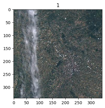
Before downloading any product, it can be useful to have a quick look at them. EO products usually offer a quicklook image, a low resolution by-product of the original data. An EOProduct has a get_quicklook method that takes care of downloading the quicklook image and returns its path. matplotlib can be used here to display the images collected.

[24]:
import matplotlib.pyplot as plt
import matplotlib.image as mpimg

quicklooks_dir = os.path.join(workspace, "quicklooks")
if not os.path.isdir(quicklooks_dir):
    os.mkdir(quicklooks_dir)

fig = plt.figure(figsize=(10, 8))
for i, product in enumerate(filtered_products, start=1):

    # This line takes care of downloading the quicklook
    quicklook_path = product.get_quicklook(output_dir=quicklooks_dir)

    img = mpimg.imread(quicklook_path)
    ax = fig.add_subplot(1, 3, i)
    ax.set_title(i)
    plt.imshow(img)
plt.tight_layout()
2026-03-26 18:11:44,037 eodag.product                    [INFO    ] Download recorded in /home/sbrunato/workspace/eodag/docs/getting_started_guide/eodag_workspace_overview/quicklooks/S2B_MSIL1C_20210609T104619_N0500_R051_T31TCJ_20230314T070018
../_images/getting_started_guide_features_overview_45_2.png

EOProducts can either be downloaded individually with download() or together with download_all() from a SearchResult. The last image is going to be downloaded, it is cloud-free and has no no-data pixel.

[25]:
product_to_download = filtered_products[0]
product_path = dag.download(product_to_download)
product_path
2026-03-26 18:11:59,874 eodag.download.base              [INFO    ] Download url: https://catalogue.dataspace.copernicus.eu/odata/v1/Products(e50e9035-fd7c-403a-bebd-769a3a499954)/$value
2026-03-26 18:15:00,776 eodag.download.base              [INFO    ] Extraction activated
2026-03-26 18:15:01,536 eodag.download.base              [INFO    ] Deleting archive S2B_MSIL1C_20210609T104619_N0500_R051_T31TCJ_20230314T070018.zip
2026-03-26 18:15:01,574 eodag.product                    [INFO    ] Remote location of the product is still available through its 'remote_location' property: https://catalogue.dataspace.copernicus.eu/odata/v1/Products(e50e9035-fd7c-403a-bebd-769a3a499954)/$value
[25]:
'/home/sbrunato/workspace/eodag/docs/getting_started_guide/eodag_workspace_overview/S2B_MSIL1C_20210609T104619_N0500_R051_T31TCJ_20230314T070018'

The location property of this product now points to a local path.

Post-process#

Now the product is downloaded, it can be post-processed with softwares such as Sen2Cor or SNAP.

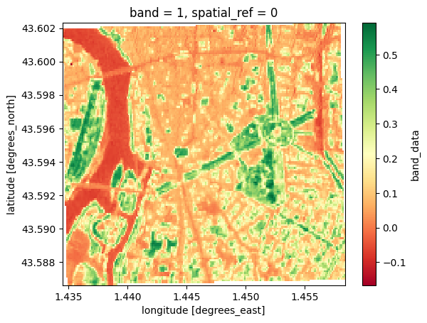
At some point eodag had some capabilities to directly post-process a product, i.e. to access its data. These capabilities, which relied on rasterio, have been ported to the Python package eodag-cube to avoid the heavy dependencies associated with GDAL in particular. Installing this package is enough to benefit from its capabilities, it is going to extend EOProduct with a to_xarray() method which returns a product’s data as a XarrayDict, dictionnary of xarray.Dataset.

The capabilities of eodag-cube are used hereafter to compute the NDVI of the downloaded product over a sub-extent of the original product (this is actually Toulouse, France).

Warning

eodag-cube needs to be installed to run correcly the following code.

[26]:
import rasterio
import warnings

# mute rasterio warnings
warnings.filterwarnings("ignore", category=rasterio.errors.NotGeoreferencedWarning)

xd = product_to_download.to_xarray()
xd
2026-03-26 18:15:14,429 eodag.download.base              [INFO    ] Product already present on this platform. Identifier: /home/sbrunato/workspace/eodag/docs/getting_started_guide/eodag_workspace_overview/S2B_MSIL1C_20210609T104619_N0500_R051_T31TCJ_20230314T070018
2026-03-26 18:15:14,429 eodag.product                    [INFO    ] Remote location of the product is still available through its 'remote_location' property: https://catalogue.dataspace.copernicus.eu/odata/v1/Products(e50e9035-fd7c-403a-bebd-769a3a499954)/$value
[26]:
XarrayDict (47)
'B01':  xarray.Dataset (band: 1, x: 1830, y: 1830)  Size: 13MB
<xarray.Dataset> Size: 13MB
Dimensions:      (band: 1, x: 1830, y: 1830)
Coordinates:
  * band         (band) int64 8B 1
  * x            (x) float64 15kB 3e+05 3.001e+05 ... 4.097e+05 4.098e+05
  * y            (y) float64 15kB 4.9e+06 4.9e+06 4.9e+06 ... 4.79e+06 4.79e+06
    spatial_ref  int64 8B 0
Data variables:
    band_data    (band, y, x) float32 13MB ...
Attributes: (12/27)
    constellation:        SENTINEL-2
    datetime:             2021-06-09T10:46:19.024000Z
    end_datetime:         2021-06-09T10:46:19.024000Z
    id:                   S2B_MSIL1C_20210609T104619_N0500_R051_T31TCJ_202303...
    instruments:          ['MSI']
    platform:             S2B
    ...                   ...
    product:type:         S2MSI1C
    s2:datastrip_id:      S2B_OPER_MSI_L1C_DS_S2RP_20230314T070018_S20210609T...
    s2:datatake_id:       GS2B_20210609T104619_022242_N05.00
    s2:datatake_type:     INS-NOBS
    sat:absolute_orbit:   22242
    sat:relative_orbit:   51
'B02':  xarray.Dataset (band: 1, x: 10980, y: 10980)  Size: 482MB
<xarray.Dataset> Size: 482MB
Dimensions:      (band: 1, x: 10980, y: 10980)
Coordinates:
  * band         (band) int64 8B 1
  * x            (x) float64 88kB 3e+05 3e+05 3e+05 ... 4.098e+05 4.098e+05
  * y            (y) float64 88kB 4.9e+06 4.9e+06 4.9e+06 ... 4.79e+06 4.79e+06
    spatial_ref  int64 8B 0
Data variables:
    band_data    (band, y, x) float32 482MB ...
Attributes: (12/27)
    constellation:        SENTINEL-2
    datetime:             2021-06-09T10:46:19.024000Z
    end_datetime:         2021-06-09T10:46:19.024000Z
    id:                   S2B_MSIL1C_20210609T104619_N0500_R051_T31TCJ_202303...
    instruments:          ['MSI']
    platform:             S2B
    ...                   ...
    product:type:         S2MSI1C
    s2:datastrip_id:      S2B_OPER_MSI_L1C_DS_S2RP_20230314T070018_S20210609T...
    s2:datatake_id:       GS2B_20210609T104619_022242_N05.00
    s2:datatake_type:     INS-NOBS
    sat:absolute_orbit:   22242
    sat:relative_orbit:   51
'B03':  xarray.Dataset (band: 1, x: 10980, y: 10980)  Size: 482MB
<xarray.Dataset> Size: 482MB
Dimensions:      (band: 1, x: 10980, y: 10980)
Coordinates:
  * band         (band) int64 8B 1
  * x            (x) float64 88kB 3e+05 3e+05 3e+05 ... 4.098e+05 4.098e+05
  * y            (y) float64 88kB 4.9e+06 4.9e+06 4.9e+06 ... 4.79e+06 4.79e+06
    spatial_ref  int64 8B 0
Data variables:
    band_data    (band, y, x) float32 482MB ...
Attributes: (12/27)
    constellation:        SENTINEL-2
    datetime:             2021-06-09T10:46:19.024000Z
    end_datetime:         2021-06-09T10:46:19.024000Z
    id:                   S2B_MSIL1C_20210609T104619_N0500_R051_T31TCJ_202303...
    instruments:          ['MSI']
    platform:             S2B
    ...                   ...
    product:type:         S2MSI1C
    s2:datastrip_id:      S2B_OPER_MSI_L1C_DS_S2RP_20230314T070018_S20210609T...
    s2:datatake_id:       GS2B_20210609T104619_022242_N05.00
    s2:datatake_type:     INS-NOBS
    sat:absolute_orbit:   22242
    sat:relative_orbit:   51
'B04':  xarray.Dataset (band: 1, x: 10980, y: 10980)  Size: 482MB
<xarray.Dataset> Size: 482MB
Dimensions:      (band: 1, x: 10980, y: 10980)
Coordinates:
  * band         (band) int64 8B 1
  * x            (x) float64 88kB 3e+05 3e+05 3e+05 ... 4.098e+05 4.098e+05
  * y            (y) float64 88kB 4.9e+06 4.9e+06 4.9e+06 ... 4.79e+06 4.79e+06
    spatial_ref  int64 8B 0
Data variables:
    band_data    (band, y, x) float32 482MB ...
Attributes: (12/27)
    constellation:        SENTINEL-2
    datetime:             2021-06-09T10:46:19.024000Z
    end_datetime:         2021-06-09T10:46:19.024000Z
    id:                   S2B_MSIL1C_20210609T104619_N0500_R051_T31TCJ_202303...
    instruments:          ['MSI']
    platform:             S2B
    ...                   ...
    product:type:         S2MSI1C
    s2:datastrip_id:      S2B_OPER_MSI_L1C_DS_S2RP_20230314T070018_S20210609T...
    s2:datatake_id:       GS2B_20210609T104619_022242_N05.00
    s2:datatake_type:     INS-NOBS
    sat:absolute_orbit:   22242
    sat:relative_orbit:   51
'B05':  xarray.Dataset (band: 1, x: 5490, y: 5490)  Size: 121MB
<xarray.Dataset> Size: 121MB
Dimensions:      (band: 1, x: 5490, y: 5490)
Coordinates:
  * band         (band) int64 8B 1
  * x            (x) float64 44kB 3e+05 3e+05 3e+05 ... 4.098e+05 4.098e+05
  * y            (y) float64 44kB 4.9e+06 4.9e+06 4.9e+06 ... 4.79e+06 4.79e+06
    spatial_ref  int64 8B 0
Data variables:
    band_data    (band, y, x) float32 121MB ...
Attributes: (12/27)
    constellation:        SENTINEL-2
    datetime:             2021-06-09T10:46:19.024000Z
    end_datetime:         2021-06-09T10:46:19.024000Z
    id:                   S2B_MSIL1C_20210609T104619_N0500_R051_T31TCJ_202303...
    instruments:          ['MSI']
    platform:             S2B
    ...                   ...
    product:type:         S2MSI1C
    s2:datastrip_id:      S2B_OPER_MSI_L1C_DS_S2RP_20230314T070018_S20210609T...
    s2:datatake_id:       GS2B_20210609T104619_022242_N05.00
    s2:datatake_type:     INS-NOBS
    sat:absolute_orbit:   22242
    sat:relative_orbit:   51
'B06':  xarray.Dataset (band: 1, x: 5490, y: 5490)  Size: 121MB
<xarray.Dataset> Size: 121MB
Dimensions:      (band: 1, x: 5490, y: 5490)
Coordinates:
  * band         (band) int64 8B 1
  * x            (x) float64 44kB 3e+05 3e+05 3e+05 ... 4.098e+05 4.098e+05
  * y            (y) float64 44kB 4.9e+06 4.9e+06 4.9e+06 ... 4.79e+06 4.79e+06
    spatial_ref  int64 8B 0
Data variables:
    band_data    (band, y, x) float32 121MB ...
Attributes: (12/27)
    constellation:        SENTINEL-2
    datetime:             2021-06-09T10:46:19.024000Z
    end_datetime:         2021-06-09T10:46:19.024000Z
    id:                   S2B_MSIL1C_20210609T104619_N0500_R051_T31TCJ_202303...
    instruments:          ['MSI']
    platform:             S2B
    ...                   ...
    product:type:         S2MSI1C
    s2:datastrip_id:      S2B_OPER_MSI_L1C_DS_S2RP_20230314T070018_S20210609T...
    s2:datatake_id:       GS2B_20210609T104619_022242_N05.00
    s2:datatake_type:     INS-NOBS
    sat:absolute_orbit:   22242
    sat:relative_orbit:   51
'B07':  xarray.Dataset (band: 1, x: 5490, y: 5490)  Size: 121MB
<xarray.Dataset> Size: 121MB
Dimensions:      (band: 1, x: 5490, y: 5490)
Coordinates:
  * band         (band) int64 8B 1
  * x            (x) float64 44kB 3e+05 3e+05 3e+05 ... 4.098e+05 4.098e+05
  * y            (y) float64 44kB 4.9e+06 4.9e+06 4.9e+06 ... 4.79e+06 4.79e+06
    spatial_ref  int64 8B 0
Data variables:
    band_data    (band, y, x) float32 121MB ...
Attributes: (12/27)
    constellation:        SENTINEL-2
    datetime:             2021-06-09T10:46:19.024000Z
    end_datetime:         2021-06-09T10:46:19.024000Z
    id:                   S2B_MSIL1C_20210609T104619_N0500_R051_T31TCJ_202303...
    instruments:          ['MSI']
    platform:             S2B
    ...                   ...
    product:type:         S2MSI1C
    s2:datastrip_id:      S2B_OPER_MSI_L1C_DS_S2RP_20230314T070018_S20210609T...
    s2:datatake_id:       GS2B_20210609T104619_022242_N05.00
    s2:datatake_type:     INS-NOBS
    sat:absolute_orbit:   22242
    sat:relative_orbit:   51
'B08':  xarray.Dataset (band: 1, x: 10980, y: 10980)  Size: 482MB
<xarray.Dataset> Size: 482MB
Dimensions:      (band: 1, x: 10980, y: 10980)
Coordinates:
  * band         (band) int64 8B 1
  * x            (x) float64 88kB 3e+05 3e+05 3e+05 ... 4.098e+05 4.098e+05
  * y            (y) float64 88kB 4.9e+06 4.9e+06 4.9e+06 ... 4.79e+06 4.79e+06
    spatial_ref  int64 8B 0
Data variables:
    band_data    (band, y, x) float32 482MB ...
Attributes: (12/27)
    constellation:        SENTINEL-2
    datetime:             2021-06-09T10:46:19.024000Z
    end_datetime:         2021-06-09T10:46:19.024000Z
    id:                   S2B_MSIL1C_20210609T104619_N0500_R051_T31TCJ_202303...
    instruments:          ['MSI']
    platform:             S2B
    ...                   ...
    product:type:         S2MSI1C
    s2:datastrip_id:      S2B_OPER_MSI_L1C_DS_S2RP_20230314T070018_S20210609T...
    s2:datatake_id:       GS2B_20210609T104619_022242_N05.00
    s2:datatake_type:     INS-NOBS
    sat:absolute_orbit:   22242
    sat:relative_orbit:   51
'B09':  xarray.Dataset (band: 1, x: 1830, y: 1830)  Size: 13MB
<xarray.Dataset> Size: 13MB
Dimensions:      (band: 1, x: 1830, y: 1830)
Coordinates:
  * band         (band) int64 8B 1
  * x            (x) float64 15kB 3e+05 3.001e+05 ... 4.097e+05 4.098e+05
  * y            (y) float64 15kB 4.9e+06 4.9e+06 4.9e+06 ... 4.79e+06 4.79e+06
    spatial_ref  int64 8B 0
Data variables:
    band_data    (band, y, x) float32 13MB ...
Attributes: (12/27)
    constellation:        SENTINEL-2
    datetime:             2021-06-09T10:46:19.024000Z
    end_datetime:         2021-06-09T10:46:19.024000Z
    id:                   S2B_MSIL1C_20210609T104619_N0500_R051_T31TCJ_202303...
    instruments:          ['MSI']
    platform:             S2B
    ...                   ...
    product:type:         S2MSI1C
    s2:datastrip_id:      S2B_OPER_MSI_L1C_DS_S2RP_20230314T070018_S20210609T...
    s2:datatake_id:       GS2B_20210609T104619_022242_N05.00
    s2:datatake_type:     INS-NOBS
    sat:absolute_orbit:   22242
    sat:relative_orbit:   51
'B10':  xarray.Dataset (band: 1, x: 1830, y: 1830)  Size: 13MB
<xarray.Dataset> Size: 13MB
Dimensions:      (band: 1, x: 1830, y: 1830)
Coordinates:
  * band         (band) int64 8B 1
  * x            (x) float64 15kB 3e+05 3.001e+05 ... 4.097e+05 4.098e+05
  * y            (y) float64 15kB 4.9e+06 4.9e+06 4.9e+06 ... 4.79e+06 4.79e+06
    spatial_ref  int64 8B 0
Data variables:
    band_data    (band, y, x) float32 13MB ...
Attributes: (12/27)
    constellation:        SENTINEL-2
    datetime:             2021-06-09T10:46:19.024000Z
    end_datetime:         2021-06-09T10:46:19.024000Z
    id:                   S2B_MSIL1C_20210609T104619_N0500_R051_T31TCJ_202303...
    instruments:          ['MSI']
    platform:             S2B
    ...                   ...
    product:type:         S2MSI1C
    s2:datastrip_id:      S2B_OPER_MSI_L1C_DS_S2RP_20230314T070018_S20210609T...
    s2:datatake_id:       GS2B_20210609T104619_022242_N05.00
    s2:datatake_type:     INS-NOBS
    sat:absolute_orbit:   22242
    sat:relative_orbit:   51
'B11':  xarray.Dataset (band: 1, x: 5490, y: 5490)  Size: 121MB
<xarray.Dataset> Size: 121MB
Dimensions:      (band: 1, x: 5490, y: 5490)
Coordinates:
  * band         (band) int64 8B 1
  * x            (x) float64 44kB 3e+05 3e+05 3e+05 ... 4.098e+05 4.098e+05
  * y            (y) float64 44kB 4.9e+06 4.9e+06 4.9e+06 ... 4.79e+06 4.79e+06
    spatial_ref  int64 8B 0
Data variables:
    band_data    (band, y, x) float32 121MB ...
Attributes: (12/27)
    constellation:        SENTINEL-2
    datetime:             2021-06-09T10:46:19.024000Z
    end_datetime:         2021-06-09T10:46:19.024000Z
    id:                   S2B_MSIL1C_20210609T104619_N0500_R051_T31TCJ_202303...
    instruments:          ['MSI']
    platform:             S2B
    ...                   ...
    product:type:         S2MSI1C
    s2:datastrip_id:      S2B_OPER_MSI_L1C_DS_S2RP_20230314T070018_S20210609T...
    s2:datatake_id:       GS2B_20210609T104619_022242_N05.00
    s2:datatake_type:     INS-NOBS
    sat:absolute_orbit:   22242
    sat:relative_orbit:   51
'B12':  xarray.Dataset (band: 1, x: 5490, y: 5490)  Size: 121MB
<xarray.Dataset> Size: 121MB
Dimensions:      (band: 1, x: 5490, y: 5490)
Coordinates:
  * band         (band) int64 8B 1
  * x            (x) float64 44kB 3e+05 3e+05 3e+05 ... 4.098e+05 4.098e+05
  * y            (y) float64 44kB 4.9e+06 4.9e+06 4.9e+06 ... 4.79e+06 4.79e+06
    spatial_ref  int64 8B 0
Data variables:
    band_data    (band, y, x) float32 121MB ...
Attributes: (12/27)
    constellation:        SENTINEL-2
    datetime:             2021-06-09T10:46:19.024000Z
    end_datetime:         2021-06-09T10:46:19.024000Z
    id:                   S2B_MSIL1C_20210609T104619_N0500_R051_T31TCJ_202303...
    instruments:          ['MSI']
    platform:             S2B
    ...                   ...
    product:type:         S2MSI1C
    s2:datastrip_id:      S2B_OPER_MSI_L1C_DS_S2RP_20230314T070018_S20210609T...
    s2:datatake_id:       GS2B_20210609T104619_022242_N05.00
    s2:datatake_type:     INS-NOBS
    sat:absolute_orbit:   22242
    sat:relative_orbit:   51
'B8A':  xarray.Dataset (band: 1, x: 5490, y: 5490)  Size: 121MB
<xarray.Dataset> Size: 121MB
Dimensions:      (band: 1, x: 5490, y: 5490)
Coordinates:
  * band         (band) int64 8B 1
  * x            (x) float64 44kB 3e+05 3e+05 3e+05 ... 4.098e+05 4.098e+05
  * y            (y) float64 44kB 4.9e+06 4.9e+06 4.9e+06 ... 4.79e+06 4.79e+06
    spatial_ref  int64 8B 0
Data variables:
    band_data    (band, y, x) float32 121MB ...
Attributes: (12/27)
    constellation:        SENTINEL-2
    datetime:             2021-06-09T10:46:19.024000Z
    end_datetime:         2021-06-09T10:46:19.024000Z
    id:                   S2B_MSIL1C_20210609T104619_N0500_R051_T31TCJ_202303...
    instruments:          ['MSI']
    platform:             S2B
    ...                   ...
    product:type:         S2MSI1C
    s2:datastrip_id:      S2B_OPER_MSI_L1C_DS_S2RP_20230314T070018_S20210609T...
    s2:datatake_id:       GS2B_20210609T104619_022242_N05.00
    s2:datatake_type:     INS-NOBS
    sat:absolute_orbit:   22242
    sat:relative_orbit:   51
'MSK_CLASSI_B00':  xarray.Dataset (band: 3, x: 1830, y: 1830)  Size: 40MB
<xarray.Dataset> Size: 40MB
Dimensions:      (band: 3, x: 1830, y: 1830)
Coordinates:
  * band         (band) int64 24B 1 2 3
  * x            (x) float64 15kB 3e+05 3.001e+05 ... 4.097e+05 4.098e+05
  * y            (y) float64 15kB 4.9e+06 4.9e+06 4.9e+06 ... 4.79e+06 4.79e+06
    spatial_ref  int64 8B 0
Data variables:
    band_data    (band, y, x) float32 40MB ...
Attributes: (12/27)
    constellation:        SENTINEL-2
    datetime:             2021-06-09T10:46:19.024000Z
    end_datetime:         2021-06-09T10:46:19.024000Z
    id:                   S2B_MSIL1C_20210609T104619_N0500_R051_T31TCJ_202303...
    instruments:          ['MSI']
    platform:             S2B
    ...                   ...
    product:type:         S2MSI1C
    s2:datastrip_id:      S2B_OPER_MSI_L1C_DS_S2RP_20230314T070018_S20210609T...
    s2:datatake_id:       GS2B_20210609T104619_022242_N05.00
    s2:datatake_type:     INS-NOBS
    sat:absolute_orbit:   22242
    sat:relative_orbit:   51
'MSK_DETFOO_B01':  xarray.Dataset (band: 1, x: 1830, y: 1830)  Size: 13MB
<xarray.Dataset> Size: 13MB
Dimensions:      (band: 1, x: 1830, y: 1830)
Coordinates:
  * band         (band) int64 8B 1
  * x            (x) float64 15kB 3e+05 3.001e+05 ... 4.097e+05 4.098e+05
  * y            (y) float64 15kB 4.9e+06 4.9e+06 4.9e+06 ... 4.79e+06 4.79e+06
    spatial_ref  int64 8B 0
Data variables:
    band_data    (band, y, x) float32 13MB ...
Attributes: (12/27)
    constellation:        SENTINEL-2
    datetime:             2021-06-09T10:46:19.024000Z
    end_datetime:         2021-06-09T10:46:19.024000Z
    id:                   S2B_MSIL1C_20210609T104619_N0500_R051_T31TCJ_202303...
    instruments:          ['MSI']
    platform:             S2B
    ...                   ...
    product:type:         S2MSI1C
    s2:datastrip_id:      S2B_OPER_MSI_L1C_DS_S2RP_20230314T070018_S20210609T...
    s2:datatake_id:       GS2B_20210609T104619_022242_N05.00
    s2:datatake_type:     INS-NOBS
    sat:absolute_orbit:   22242
    sat:relative_orbit:   51
'MSK_DETFOO_B02':  xarray.Dataset (band: 1, x: 10980, y: 10980)  Size: 482MB
<xarray.Dataset> Size: 482MB
Dimensions:      (band: 1, x: 10980, y: 10980)
Coordinates:
  * band         (band) int64 8B 1
  * x            (x) float64 88kB 3e+05 3e+05 3e+05 ... 4.098e+05 4.098e+05
  * y            (y) float64 88kB 4.9e+06 4.9e+06 4.9e+06 ... 4.79e+06 4.79e+06
    spatial_ref  int64 8B 0
Data variables:
    band_data    (band, y, x) float32 482MB ...
Attributes: (12/27)
    constellation:        SENTINEL-2
    datetime:             2021-06-09T10:46:19.024000Z
    end_datetime:         2021-06-09T10:46:19.024000Z
    id:                   S2B_MSIL1C_20210609T104619_N0500_R051_T31TCJ_202303...
    instruments:          ['MSI']
    platform:             S2B
    ...                   ...
    product:type:         S2MSI1C
    s2:datastrip_id:      S2B_OPER_MSI_L1C_DS_S2RP_20230314T070018_S20210609T...
    s2:datatake_id:       GS2B_20210609T104619_022242_N05.00
    s2:datatake_type:     INS-NOBS
    sat:absolute_orbit:   22242
    sat:relative_orbit:   51
'MSK_DETFOO_B03':  xarray.Dataset (band: 1, x: 10980, y: 10980)  Size: 482MB
<xarray.Dataset> Size: 482MB
Dimensions:      (band: 1, x: 10980, y: 10980)
Coordinates:
  * band         (band) int64 8B 1
  * x            (x) float64 88kB 3e+05 3e+05 3e+05 ... 4.098e+05 4.098e+05
  * y            (y) float64 88kB 4.9e+06 4.9e+06 4.9e+06 ... 4.79e+06 4.79e+06
    spatial_ref  int64 8B 0
Data variables:
    band_data    (band, y, x) float32 482MB ...
Attributes: (12/27)
    constellation:        SENTINEL-2
    datetime:             2021-06-09T10:46:19.024000Z
    end_datetime:         2021-06-09T10:46:19.024000Z
    id:                   S2B_MSIL1C_20210609T104619_N0500_R051_T31TCJ_202303...
    instruments:          ['MSI']
    platform:             S2B
    ...                   ...
    product:type:         S2MSI1C
    s2:datastrip_id:      S2B_OPER_MSI_L1C_DS_S2RP_20230314T070018_S20210609T...
    s2:datatake_id:       GS2B_20210609T104619_022242_N05.00
    s2:datatake_type:     INS-NOBS
    sat:absolute_orbit:   22242
    sat:relative_orbit:   51
'MSK_DETFOO_B04':  xarray.Dataset (band: 1, x: 10980, y: 10980)  Size: 482MB
<xarray.Dataset> Size: 482MB
Dimensions:      (band: 1, x: 10980, y: 10980)
Coordinates:
  * band         (band) int64 8B 1
  * x            (x) float64 88kB 3e+05 3e+05 3e+05 ... 4.098e+05 4.098e+05
  * y            (y) float64 88kB 4.9e+06 4.9e+06 4.9e+06 ... 4.79e+06 4.79e+06
    spatial_ref  int64 8B 0
Data variables:
    band_data    (band, y, x) float32 482MB ...
Attributes: (12/27)
    constellation:        SENTINEL-2
    datetime:             2021-06-09T10:46:19.024000Z
    end_datetime:         2021-06-09T10:46:19.024000Z
    id:                   S2B_MSIL1C_20210609T104619_N0500_R051_T31TCJ_202303...
    instruments:          ['MSI']
    platform:             S2B
    ...                   ...
    product:type:         S2MSI1C
    s2:datastrip_id:      S2B_OPER_MSI_L1C_DS_S2RP_20230314T070018_S20210609T...
    s2:datatake_id:       GS2B_20210609T104619_022242_N05.00
    s2:datatake_type:     INS-NOBS
    sat:absolute_orbit:   22242
    sat:relative_orbit:   51
'MSK_DETFOO_B05':  xarray.Dataset (band: 1, x: 5490, y: 5490)  Size: 121MB
<xarray.Dataset> Size: 121MB
Dimensions:      (band: 1, x: 5490, y: 5490)
Coordinates:
  * band         (band) int64 8B 1
  * x            (x) float64 44kB 3e+05 3e+05 3e+05 ... 4.098e+05 4.098e+05
  * y            (y) float64 44kB 4.9e+06 4.9e+06 4.9e+06 ... 4.79e+06 4.79e+06
    spatial_ref  int64 8B 0
Data variables:
    band_data    (band, y, x) float32 121MB ...
Attributes: (12/27)
    constellation:        SENTINEL-2
    datetime:             2021-06-09T10:46:19.024000Z
    end_datetime:         2021-06-09T10:46:19.024000Z
    id:                   S2B_MSIL1C_20210609T104619_N0500_R051_T31TCJ_202303...
    instruments:          ['MSI']
    platform:             S2B
    ...                   ...
    product:type:         S2MSI1C
    s2:datastrip_id:      S2B_OPER_MSI_L1C_DS_S2RP_20230314T070018_S20210609T...
    s2:datatake_id:       GS2B_20210609T104619_022242_N05.00
    s2:datatake_type:     INS-NOBS
    sat:absolute_orbit:   22242
    sat:relative_orbit:   51
'MSK_DETFOO_B06':  xarray.Dataset (band: 1, x: 5490, y: 5490)  Size: 121MB
<xarray.Dataset> Size: 121MB
Dimensions:      (band: 1, x: 5490, y: 5490)
Coordinates:
  * band         (band) int64 8B 1
  * x            (x) float64 44kB 3e+05 3e+05 3e+05 ... 4.098e+05 4.098e+05
  * y            (y) float64 44kB 4.9e+06 4.9e+06 4.9e+06 ... 4.79e+06 4.79e+06
    spatial_ref  int64 8B 0
Data variables:
    band_data    (band, y, x) float32 121MB ...
Attributes: (12/27)
    constellation:        SENTINEL-2
    datetime:             2021-06-09T10:46:19.024000Z
    end_datetime:         2021-06-09T10:46:19.024000Z
    id:                   S2B_MSIL1C_20210609T104619_N0500_R051_T31TCJ_202303...
    instruments:          ['MSI']
    platform:             S2B
    ...                   ...
    product:type:         S2MSI1C
    s2:datastrip_id:      S2B_OPER_MSI_L1C_DS_S2RP_20230314T070018_S20210609T...
    s2:datatake_id:       GS2B_20210609T104619_022242_N05.00
    s2:datatake_type:     INS-NOBS
    sat:absolute_orbit:   22242
    sat:relative_orbit:   51
'MSK_DETFOO_B07':  xarray.Dataset (band: 1, x: 5490, y: 5490)  Size: 121MB
<xarray.Dataset> Size: 121MB
Dimensions:      (band: 1, x: 5490, y: 5490)
Coordinates:
  * band         (band) int64 8B 1
  * x            (x) float64 44kB 3e+05 3e+05 3e+05 ... 4.098e+05 4.098e+05
  * y            (y) float64 44kB 4.9e+06 4.9e+06 4.9e+06 ... 4.79e+06 4.79e+06
    spatial_ref  int64 8B 0
Data variables:
    band_data    (band, y, x) float32 121MB ...
Attributes: (12/27)
    constellation:        SENTINEL-2
    datetime:             2021-06-09T10:46:19.024000Z
    end_datetime:         2021-06-09T10:46:19.024000Z
    id:                   S2B_MSIL1C_20210609T104619_N0500_R051_T31TCJ_202303...
    instruments:          ['MSI']
    platform:             S2B
    ...                   ...
    product:type:         S2MSI1C
    s2:datastrip_id:      S2B_OPER_MSI_L1C_DS_S2RP_20230314T070018_S20210609T...
    s2:datatake_id:       GS2B_20210609T104619_022242_N05.00
    s2:datatake_type:     INS-NOBS
    sat:absolute_orbit:   22242
    sat:relative_orbit:   51
'MSK_DETFOO_B08':  xarray.Dataset (band: 1, x: 10980, y: 10980)  Size: 482MB
<xarray.Dataset> Size: 482MB
Dimensions:      (band: 1, x: 10980, y: 10980)
Coordinates:
  * band         (band) int64 8B 1
  * x            (x) float64 88kB 3e+05 3e+05 3e+05 ... 4.098e+05 4.098e+05
  * y            (y) float64 88kB 4.9e+06 4.9e+06 4.9e+06 ... 4.79e+06 4.79e+06
    spatial_ref  int64 8B 0
Data variables:
    band_data    (band, y, x) float32 482MB ...
Attributes: (12/27)
    constellation:        SENTINEL-2
    datetime:             2021-06-09T10:46:19.024000Z
    end_datetime:         2021-06-09T10:46:19.024000Z
    id:                   S2B_MSIL1C_20210609T104619_N0500_R051_T31TCJ_202303...
    instruments:          ['MSI']
    platform:             S2B
    ...                   ...
    product:type:         S2MSI1C
    s2:datastrip_id:      S2B_OPER_MSI_L1C_DS_S2RP_20230314T070018_S20210609T...
    s2:datatake_id:       GS2B_20210609T104619_022242_N05.00
    s2:datatake_type:     INS-NOBS
    sat:absolute_orbit:   22242
    sat:relative_orbit:   51
'MSK_DETFOO_B09':  xarray.Dataset (band: 1, x: 1830, y: 1830)  Size: 13MB
<xarray.Dataset> Size: 13MB
Dimensions:      (band: 1, x: 1830, y: 1830)
Coordinates:
  * band         (band) int64 8B 1
  * x            (x) float64 15kB 3e+05 3.001e+05 ... 4.097e+05 4.098e+05
  * y            (y) float64 15kB 4.9e+06 4.9e+06 4.9e+06 ... 4.79e+06 4.79e+06
    spatial_ref  int64 8B 0
Data variables:
    band_data    (band, y, x) float32 13MB ...
Attributes: (12/27)
    constellation:        SENTINEL-2
    datetime:             2021-06-09T10:46:19.024000Z
    end_datetime:         2021-06-09T10:46:19.024000Z
    id:                   S2B_MSIL1C_20210609T104619_N0500_R051_T31TCJ_202303...
    instruments:          ['MSI']
    platform:             S2B
    ...                   ...
    product:type:         S2MSI1C
    s2:datastrip_id:      S2B_OPER_MSI_L1C_DS_S2RP_20230314T070018_S20210609T...
    s2:datatake_id:       GS2B_20210609T104619_022242_N05.00
    s2:datatake_type:     INS-NOBS
    sat:absolute_orbit:   22242
    sat:relative_orbit:   51
'MSK_DETFOO_B10':  xarray.Dataset (band: 1, x: 1830, y: 1830)  Size: 13MB
<xarray.Dataset> Size: 13MB
Dimensions:      (band: 1, x: 1830, y: 1830)
Coordinates:
  * band         (band) int64 8B 1
  * x            (x) float64 15kB 3e+05 3.001e+05 ... 4.097e+05 4.098e+05
  * y            (y) float64 15kB 4.9e+06 4.9e+06 4.9e+06 ... 4.79e+06 4.79e+06
    spatial_ref  int64 8B 0
Data variables:
    band_data    (band, y, x) float32 13MB ...
Attributes: (12/27)
    constellation:        SENTINEL-2
    datetime:             2021-06-09T10:46:19.024000Z
    end_datetime:         2021-06-09T10:46:19.024000Z
    id:                   S2B_MSIL1C_20210609T104619_N0500_R051_T31TCJ_202303...
    instruments:          ['MSI']
    platform:             S2B
    ...                   ...
    product:type:         S2MSI1C
    s2:datastrip_id:      S2B_OPER_MSI_L1C_DS_S2RP_20230314T070018_S20210609T...
    s2:datatake_id:       GS2B_20210609T104619_022242_N05.00
    s2:datatake_type:     INS-NOBS
    sat:absolute_orbit:   22242
    sat:relative_orbit:   51
'MSK_DETFOO_B11':  xarray.Dataset (band: 1, x: 5490, y: 5490)  Size: 121MB
<xarray.Dataset> Size: 121MB
Dimensions:      (band: 1, x: 5490, y: 5490)
Coordinates:
  * band         (band) int64 8B 1
  * x            (x) float64 44kB 3e+05 3e+05 3e+05 ... 4.098e+05 4.098e+05
  * y            (y) float64 44kB 4.9e+06 4.9e+06 4.9e+06 ... 4.79e+06 4.79e+06
    spatial_ref  int64 8B 0
Data variables:
    band_data    (band, y, x) float32 121MB ...
Attributes: (12/27)
    constellation:        SENTINEL-2
    datetime:             2021-06-09T10:46:19.024000Z
    end_datetime:         2021-06-09T10:46:19.024000Z
    id:                   S2B_MSIL1C_20210609T104619_N0500_R051_T31TCJ_202303...
    instruments:          ['MSI']
    platform:             S2B
    ...                   ...
    product:type:         S2MSI1C
    s2:datastrip_id:      S2B_OPER_MSI_L1C_DS_S2RP_20230314T070018_S20210609T...
    s2:datatake_id:       GS2B_20210609T104619_022242_N05.00
    s2:datatake_type:     INS-NOBS
    sat:absolute_orbit:   22242
    sat:relative_orbit:   51
'MSK_DETFOO_B12':  xarray.Dataset (band: 1, x: 5490, y: 5490)  Size: 121MB
<xarray.Dataset> Size: 121MB
Dimensions:      (band: 1, x: 5490, y: 5490)
Coordinates:
  * band         (band) int64 8B 1
  * x            (x) float64 44kB 3e+05 3e+05 3e+05 ... 4.098e+05 4.098e+05
  * y            (y) float64 44kB 4.9e+06 4.9e+06 4.9e+06 ... 4.79e+06 4.79e+06
    spatial_ref  int64 8B 0
Data variables:
    band_data    (band, y, x) float32 121MB ...
Attributes: (12/27)
    constellation:        SENTINEL-2
    datetime:             2021-06-09T10:46:19.024000Z
    end_datetime:         2021-06-09T10:46:19.024000Z
    id:                   S2B_MSIL1C_20210609T104619_N0500_R051_T31TCJ_202303...
    instruments:          ['MSI']
    platform:             S2B
    ...                   ...
    product:type:         S2MSI1C
    s2:datastrip_id:      S2B_OPER_MSI_L1C_DS_S2RP_20230314T070018_S20210609T...
    s2:datatake_id:       GS2B_20210609T104619_022242_N05.00
    s2:datatake_type:     INS-NOBS
    sat:absolute_orbit:   22242
    sat:relative_orbit:   51
'MSK_DETFOO_B8A':  xarray.Dataset (band: 1, x: 5490, y: 5490)  Size: 121MB
<xarray.Dataset> Size: 121MB
Dimensions:      (band: 1, x: 5490, y: 5490)
Coordinates:
  * band         (band) int64 8B 1
  * x            (x) float64 44kB 3e+05 3e+05 3e+05 ... 4.098e+05 4.098e+05
  * y            (y) float64 44kB 4.9e+06 4.9e+06 4.9e+06 ... 4.79e+06 4.79e+06
    spatial_ref  int64 8B 0
Data variables:
    band_data    (band, y, x) float32 121MB ...
Attributes: (12/27)
    constellation:        SENTINEL-2
    datetime:             2021-06-09T10:46:19.024000Z
    end_datetime:         2021-06-09T10:46:19.024000Z
    id:                   S2B_MSIL1C_20210609T104619_N0500_R051_T31TCJ_202303...
    instruments:          ['MSI']
    platform:             S2B
    ...                   ...
    product:type:         S2MSI1C
    s2:datastrip_id:      S2B_OPER_MSI_L1C_DS_S2RP_20230314T070018_S20210609T...
    s2:datatake_id:       GS2B_20210609T104619_022242_N05.00
    s2:datatake_type:     INS-NOBS
    sat:absolute_orbit:   22242
    sat:relative_orbit:   51
'MSK_QUALIT_B01':  xarray.Dataset (band: 8, x: 1830, y: 1830)  Size: 107MB
<xarray.Dataset> Size: 107MB
Dimensions:      (band: 8, x: 1830, y: 1830)
Coordinates:
  * band         (band) int64 64B 1 2 3 4 5 6 7 8
  * x            (x) float64 15kB 3e+05 3.001e+05 ... 4.097e+05 4.098e+05
  * y            (y) float64 15kB 4.9e+06 4.9e+06 4.9e+06 ... 4.79e+06 4.79e+06
    spatial_ref  int64 8B 0
Data variables:
    band_data    (band, y, x) float32 107MB ...
Attributes: (12/27)
    constellation:        SENTINEL-2
    datetime:             2021-06-09T10:46:19.024000Z
    end_datetime:         2021-06-09T10:46:19.024000Z
    id:                   S2B_MSIL1C_20210609T104619_N0500_R051_T31TCJ_202303...
    instruments:          ['MSI']
    platform:             S2B
    ...                   ...
    product:type:         S2MSI1C
    s2:datastrip_id:      S2B_OPER_MSI_L1C_DS_S2RP_20230314T070018_S20210609T...
    s2:datatake_id:       GS2B_20210609T104619_022242_N05.00
    s2:datatake_type:     INS-NOBS
    sat:absolute_orbit:   22242
    sat:relative_orbit:   51
'MSK_QUALIT_B02':  xarray.Dataset (band: 8, x: 10980, y: 10980)  Size: 4GB
<xarray.Dataset> Size: 4GB
Dimensions:      (band: 8, x: 10980, y: 10980)
Coordinates:
  * band         (band) int64 64B 1 2 3 4 5 6 7 8
  * x            (x) float64 88kB 3e+05 3e+05 3e+05 ... 4.098e+05 4.098e+05
  * y            (y) float64 88kB 4.9e+06 4.9e+06 4.9e+06 ... 4.79e+06 4.79e+06
    spatial_ref  int64 8B 0
Data variables:
    band_data    (band, y, x) float32 4GB ...
Attributes: (12/27)
    constellation:        SENTINEL-2
    datetime:             2021-06-09T10:46:19.024000Z
    end_datetime:         2021-06-09T10:46:19.024000Z
    id:                   S2B_MSIL1C_20210609T104619_N0500_R051_T31TCJ_202303...
    instruments:          ['MSI']
    platform:             S2B
    ...                   ...
    product:type:         S2MSI1C
    s2:datastrip_id:      S2B_OPER_MSI_L1C_DS_S2RP_20230314T070018_S20210609T...
    s2:datatake_id:       GS2B_20210609T104619_022242_N05.00
    s2:datatake_type:     INS-NOBS
    sat:absolute_orbit:   22242
    sat:relative_orbit:   51
'MSK_QUALIT_B03':  xarray.Dataset (band: 8, x: 10980, y: 10980)  Size: 4GB
<xarray.Dataset> Size: 4GB
Dimensions:      (band: 8, x: 10980, y: 10980)
Coordinates:
  * band         (band) int64 64B 1 2 3 4 5 6 7 8
  * x            (x) float64 88kB 3e+05 3e+05 3e+05 ... 4.098e+05 4.098e+05
  * y            (y) float64 88kB 4.9e+06 4.9e+06 4.9e+06 ... 4.79e+06 4.79e+06
    spatial_ref  int64 8B 0
Data variables:
    band_data    (band, y, x) float32 4GB ...
Attributes: (12/27)
    constellation:        SENTINEL-2
    datetime:             2021-06-09T10:46:19.024000Z
    end_datetime:         2021-06-09T10:46:19.024000Z
    id:                   S2B_MSIL1C_20210609T104619_N0500_R051_T31TCJ_202303...
    instruments:          ['MSI']
    platform:             S2B
    ...                   ...
    product:type:         S2MSI1C
    s2:datastrip_id:      S2B_OPER_MSI_L1C_DS_S2RP_20230314T070018_S20210609T...
    s2:datatake_id:       GS2B_20210609T104619_022242_N05.00
    s2:datatake_type:     INS-NOBS
    sat:absolute_orbit:   22242
    sat:relative_orbit:   51
'MSK_QUALIT_B04':  xarray.Dataset (band: 8, x: 10980, y: 10980)  Size: 4GB
<xarray.Dataset> Size: 4GB
Dimensions:      (band: 8, x: 10980, y: 10980)
Coordinates:
  * band         (band) int64 64B 1 2 3 4 5 6 7 8
  * x            (x) float64 88kB 3e+05 3e+05 3e+05 ... 4.098e+05 4.098e+05
  * y            (y) float64 88kB 4.9e+06 4.9e+06 4.9e+06 ... 4.79e+06 4.79e+06
    spatial_ref  int64 8B 0
Data variables:
    band_data    (band, y, x) float32 4GB ...
Attributes: (12/27)
    constellation:        SENTINEL-2
    datetime:             2021-06-09T10:46:19.024000Z
    end_datetime:         2021-06-09T10:46:19.024000Z
    id:                   S2B_MSIL1C_20210609T104619_N0500_R051_T31TCJ_202303...
    instruments:          ['MSI']
    platform:             S2B
    ...                   ...
    product:type:         S2MSI1C
    s2:datastrip_id:      S2B_OPER_MSI_L1C_DS_S2RP_20230314T070018_S20210609T...
    s2:datatake_id:       GS2B_20210609T104619_022242_N05.00
    s2:datatake_type:     INS-NOBS
    sat:absolute_orbit:   22242
    sat:relative_orbit:   51
'MSK_QUALIT_B05':  xarray.Dataset (band: 8, x: 5490, y: 5490)  Size: 965MB
<xarray.Dataset> Size: 965MB
Dimensions:      (band: 8, x: 5490, y: 5490)
Coordinates:
  * band         (band) int64 64B 1 2 3 4 5 6 7 8
  * x            (x) float64 44kB 3e+05 3e+05 3e+05 ... 4.098e+05 4.098e+05
  * y            (y) float64 44kB 4.9e+06 4.9e+06 4.9e+06 ... 4.79e+06 4.79e+06
    spatial_ref  int64 8B 0
Data variables:
    band_data    (band, y, x) float32 964MB ...
Attributes: (12/27)
    constellation:        SENTINEL-2
    datetime:             2021-06-09T10:46:19.024000Z
    end_datetime:         2021-06-09T10:46:19.024000Z
    id:                   S2B_MSIL1C_20210609T104619_N0500_R051_T31TCJ_202303...
    instruments:          ['MSI']
    platform:             S2B
    ...                   ...
    product:type:         S2MSI1C
    s2:datastrip_id:      S2B_OPER_MSI_L1C_DS_S2RP_20230314T070018_S20210609T...
    s2:datatake_id:       GS2B_20210609T104619_022242_N05.00
    s2:datatake_type:     INS-NOBS
    sat:absolute_orbit:   22242
    sat:relative_orbit:   51
'MSK_QUALIT_B06':  xarray.Dataset (band: 8, x: 5490, y: 5490)  Size: 965MB
<xarray.Dataset> Size: 965MB
Dimensions:      (band: 8, x: 5490, y: 5490)
Coordinates:
  * band         (band) int64 64B 1 2 3 4 5 6 7 8
  * x            (x) float64 44kB 3e+05 3e+05 3e+05 ... 4.098e+05 4.098e+05
  * y            (y) float64 44kB 4.9e+06 4.9e+06 4.9e+06 ... 4.79e+06 4.79e+06
    spatial_ref  int64 8B 0
Data variables:
    band_data    (band, y, x) float32 964MB ...
Attributes: (12/27)
    constellation:        SENTINEL-2
    datetime:             2021-06-09T10:46:19.024000Z
    end_datetime:         2021-06-09T10:46:19.024000Z
    id:                   S2B_MSIL1C_20210609T104619_N0500_R051_T31TCJ_202303...
    instruments:          ['MSI']
    platform:             S2B
    ...                   ...
    product:type:         S2MSI1C
    s2:datastrip_id:      S2B_OPER_MSI_L1C_DS_S2RP_20230314T070018_S20210609T...
    s2:datatake_id:       GS2B_20210609T104619_022242_N05.00
    s2:datatake_type:     INS-NOBS
    sat:absolute_orbit:   22242
    sat:relative_orbit:   51
'MSK_QUALIT_B07':  xarray.Dataset (band: 8, x: 5490, y: 5490)  Size: 965MB
<xarray.Dataset> Size: 965MB
Dimensions:      (band: 8, x: 5490, y: 5490)
Coordinates:
  * band         (band) int64 64B 1 2 3 4 5 6 7 8
  * x            (x) float64 44kB 3e+05 3e+05 3e+05 ... 4.098e+05 4.098e+05
  * y            (y) float64 44kB 4.9e+06 4.9e+06 4.9e+06 ... 4.79e+06 4.79e+06
    spatial_ref  int64 8B 0
Data variables:
    band_data    (band, y, x) float32 964MB ...
Attributes: (12/27)
    constellation:        SENTINEL-2
    datetime:             2021-06-09T10:46:19.024000Z
    end_datetime:         2021-06-09T10:46:19.024000Z
    id:                   S2B_MSIL1C_20210609T104619_N0500_R051_T31TCJ_202303...
    instruments:          ['MSI']
    platform:             S2B
    ...                   ...
    product:type:         S2MSI1C
    s2:datastrip_id:      S2B_OPER_MSI_L1C_DS_S2RP_20230314T070018_S20210609T...
    s2:datatake_id:       GS2B_20210609T104619_022242_N05.00
    s2:datatake_type:     INS-NOBS
    sat:absolute_orbit:   22242
    sat:relative_orbit:   51
'MSK_QUALIT_B08':  xarray.Dataset (band: 8, x: 10980, y: 10980)  Size: 4GB
<xarray.Dataset> Size: 4GB
Dimensions:      (band: 8, x: 10980, y: 10980)
Coordinates:
  * band         (band) int64 64B 1 2 3 4 5 6 7 8
  * x            (x) float64 88kB 3e+05 3e+05 3e+05 ... 4.098e+05 4.098e+05
  * y            (y) float64 88kB 4.9e+06 4.9e+06 4.9e+06 ... 4.79e+06 4.79e+06
    spatial_ref  int64 8B 0
Data variables:
    band_data    (band, y, x) float32 4GB ...
Attributes: (12/27)
    constellation:        SENTINEL-2
    datetime:             2021-06-09T10:46:19.024000Z
    end_datetime:         2021-06-09T10:46:19.024000Z
    id:                   S2B_MSIL1C_20210609T104619_N0500_R051_T31TCJ_202303...
    instruments:          ['MSI']
    platform:             S2B
    ...                   ...
    product:type:         S2MSI1C
    s2:datastrip_id:      S2B_OPER_MSI_L1C_DS_S2RP_20230314T070018_S20210609T...
    s2:datatake_id:       GS2B_20210609T104619_022242_N05.00
    s2:datatake_type:     INS-NOBS
    sat:absolute_orbit:   22242
    sat:relative_orbit:   51
'MSK_QUALIT_B09':  xarray.Dataset (band: 8, x: 1830, y: 1830)  Size: 107MB
<xarray.Dataset> Size: 107MB
Dimensions:      (band: 8, x: 1830, y: 1830)
Coordinates:
  * band         (band) int64 64B 1 2 3 4 5 6 7 8
  * x            (x) float64 15kB 3e+05 3.001e+05 ... 4.097e+05 4.098e+05
  * y            (y) float64 15kB 4.9e+06 4.9e+06 4.9e+06 ... 4.79e+06 4.79e+06
    spatial_ref  int64 8B 0
Data variables:
    band_data    (band, y, x) float32 107MB ...
Attributes: (12/27)
    constellation:        SENTINEL-2
    datetime:             2021-06-09T10:46:19.024000Z
    end_datetime:         2021-06-09T10:46:19.024000Z
    id:                   S2B_MSIL1C_20210609T104619_N0500_R051_T31TCJ_202303...
    instruments:          ['MSI']
    platform:             S2B
    ...                   ...
    product:type:         S2MSI1C
    s2:datastrip_id:      S2B_OPER_MSI_L1C_DS_S2RP_20230314T070018_S20210609T...
    s2:datatake_id:       GS2B_20210609T104619_022242_N05.00
    s2:datatake_type:     INS-NOBS
    sat:absolute_orbit:   22242
    sat:relative_orbit:   51
'MSK_QUALIT_B10':  xarray.Dataset (band: 8, x: 1830, y: 1830)  Size: 107MB
<xarray.Dataset> Size: 107MB
Dimensions:      (band: 8, x: 1830, y: 1830)
Coordinates:
  * band         (band) int64 64B 1 2 3 4 5 6 7 8
  * x            (x) float64 15kB 3e+05 3.001e+05 ... 4.097e+05 4.098e+05
  * y            (y) float64 15kB 4.9e+06 4.9e+06 4.9e+06 ... 4.79e+06 4.79e+06
    spatial_ref  int64 8B 0
Data variables:
    band_data    (band, y, x) float32 107MB ...
Attributes: (12/27)
    constellation:        SENTINEL-2
    datetime:             2021-06-09T10:46:19.024000Z
    end_datetime:         2021-06-09T10:46:19.024000Z
    id:                   S2B_MSIL1C_20210609T104619_N0500_R051_T31TCJ_202303...
    instruments:          ['MSI']
    platform:             S2B
    ...                   ...
    product:type:         S2MSI1C
    s2:datastrip_id:      S2B_OPER_MSI_L1C_DS_S2RP_20230314T070018_S20210609T...
    s2:datatake_id:       GS2B_20210609T104619_022242_N05.00
    s2:datatake_type:     INS-NOBS
    sat:absolute_orbit:   22242
    sat:relative_orbit:   51
'MSK_QUALIT_B11':  xarray.Dataset (band: 8, x: 5490, y: 5490)  Size: 965MB
<xarray.Dataset> Size: 965MB
Dimensions:      (band: 8, x: 5490, y: 5490)
Coordinates:
  * band         (band) int64 64B 1 2 3 4 5 6 7 8
  * x            (x) float64 44kB 3e+05 3e+05 3e+05 ... 4.098e+05 4.098e+05
  * y            (y) float64 44kB 4.9e+06 4.9e+06 4.9e+06 ... 4.79e+06 4.79e+06
    spatial_ref  int64 8B 0
Data variables:
    band_data    (band, y, x) float32 964MB ...
Attributes: (12/27)
    constellation:        SENTINEL-2
    datetime:             2021-06-09T10:46:19.024000Z
    end_datetime:         2021-06-09T10:46:19.024000Z
    id:                   S2B_MSIL1C_20210609T104619_N0500_R051_T31TCJ_202303...
    instruments:          ['MSI']
    platform:             S2B
    ...                   ...
    product:type:         S2MSI1C
    s2:datastrip_id:      S2B_OPER_MSI_L1C_DS_S2RP_20230314T070018_S20210609T...
    s2:datatake_id:       GS2B_20210609T104619_022242_N05.00
    s2:datatake_type:     INS-NOBS
    sat:absolute_orbit:   22242
    sat:relative_orbit:   51
'MSK_QUALIT_B12':  xarray.Dataset (band: 8, x: 5490, y: 5490)  Size: 965MB
<xarray.Dataset> Size: 965MB
Dimensions:      (band: 8, x: 5490, y: 5490)
Coordinates:
  * band         (band) int64 64B 1 2 3 4 5 6 7 8
  * x            (x) float64 44kB 3e+05 3e+05 3e+05 ... 4.098e+05 4.098e+05
  * y            (y) float64 44kB 4.9e+06 4.9e+06 4.9e+06 ... 4.79e+06 4.79e+06
    spatial_ref  int64 8B 0
Data variables:
    band_data    (band, y, x) float32 964MB ...
Attributes: (12/27)
    constellation:        SENTINEL-2
    datetime:             2021-06-09T10:46:19.024000Z
    end_datetime:         2021-06-09T10:46:19.024000Z
    id:                   S2B_MSIL1C_20210609T104619_N0500_R051_T31TCJ_202303...
    instruments:          ['MSI']
    platform:             S2B
    ...                   ...
    product:type:         S2MSI1C
    s2:datastrip_id:      S2B_OPER_MSI_L1C_DS_S2RP_20230314T070018_S20210609T...
    s2:datatake_id:       GS2B_20210609T104619_022242_N05.00
    s2:datatake_type:     INS-NOBS
    sat:absolute_orbit:   22242
    sat:relative_orbit:   51
'MSK_QUALIT_B8A':  xarray.Dataset (band: 8, x: 5490, y: 5490)  Size: 965MB
<xarray.Dataset> Size: 965MB
Dimensions:      (band: 8, x: 5490, y: 5490)
Coordinates:
  * band         (band) int64 64B 1 2 3 4 5 6 7 8
  * x            (x) float64 44kB 3e+05 3e+05 3e+05 ... 4.098e+05 4.098e+05
  * y            (y) float64 44kB 4.9e+06 4.9e+06 4.9e+06 ... 4.79e+06 4.79e+06
    spatial_ref  int64 8B 0
Data variables:
    band_data    (band, y, x) float32 964MB ...
Attributes: (12/27)
    constellation:        SENTINEL-2
    datetime:             2021-06-09T10:46:19.024000Z
    end_datetime:         2021-06-09T10:46:19.024000Z
    id:                   S2B_MSIL1C_20210609T104619_N0500_R051_T31TCJ_202303...
    instruments:          ['MSI']
    platform:             S2B
    ...                   ...
    product:type:         S2MSI1C
    s2:datastrip_id:      S2B_OPER_MSI_L1C_DS_S2RP_20230314T070018_S20210609T...
    s2:datatake_id:       GS2B_20210609T104619_022242_N05.00
    s2:datatake_type:     INS-NOBS
    sat:absolute_orbit:   22242
    sat:relative_orbit:   51
'PVI':  xarray.Dataset (band: 3, x: 343, y: 343)  Size: 1MB
<xarray.Dataset> Size: 1MB
Dimensions:      (band: 3, x: 343, y: 343)
Coordinates:
  * band         (band) int64 24B 1 2 3
  * x            (x) float64 3kB 3.002e+05 3.005e+05 ... 4.093e+05 4.096e+05
  * y            (y) float64 3kB 4.9e+06 4.9e+06 ... 4.791e+06 4.79e+06
    spatial_ref  int64 8B 0
Data variables:
    band_data    (band, y, x) float32 1MB ...
Attributes: (12/27)
    constellation:        SENTINEL-2
    datetime:             2021-06-09T10:46:19.024000Z
    end_datetime:         2021-06-09T10:46:19.024000Z
    id:                   S2B_MSIL1C_20210609T104619_N0500_R051_T31TCJ_202303...
    instruments:          ['MSI']
    platform:             S2B
    ...                   ...
    product:type:         S2MSI1C
    s2:datastrip_id:      S2B_OPER_MSI_L1C_DS_S2RP_20230314T070018_S20210609T...
    s2:datatake_id:       GS2B_20210609T104619_022242_N05.00
    s2:datatake_type:     INS-NOBS
    sat:absolute_orbit:   22242
    sat:relative_orbit:   51
'TCI':  xarray.Dataset (band: 3, x: 10980, y: 10980)  Size: 1GB
<xarray.Dataset> Size: 1GB
Dimensions:      (band: 3, x: 10980, y: 10980)
Coordinates:
  * band         (band) int64 24B 1 2 3
  * x            (x) float64 88kB 3e+05 3e+05 3e+05 ... 4.098e+05 4.098e+05
  * y            (y) float64 88kB 4.9e+06 4.9e+06 4.9e+06 ... 4.79e+06 4.79e+06
    spatial_ref  int64 8B 0
Data variables:
    band_data    (band, y, x) float32 1GB ...
Attributes: (12/27)
    constellation:        SENTINEL-2
    datetime:             2021-06-09T10:46:19.024000Z
    end_datetime:         2021-06-09T10:46:19.024000Z
    id:                   S2B_MSIL1C_20210609T104619_N0500_R051_T31TCJ_202303...
    instruments:          ['MSI']
    platform:             S2B
    ...                   ...
    product:type:         S2MSI1C
    s2:datastrip_id:      S2B_OPER_MSI_L1C_DS_S2RP_20230314T070018_S20210609T...
    s2:datatake_id:       GS2B_20210609T104619_022242_N05.00
    s2:datatake_type:     INS-NOBS
    sat:absolute_orbit:   22242
    sat:relative_orbit:   51
'banner_1.png':  xarray.Dataset (band: 4, x: 294, y: 132)  Size: 624kB
<xarray.Dataset> Size: 624kB
Dimensions:      (band: 4, x: 294, y: 132)
Coordinates:
  * band         (band) int64 32B 1 2 3 4
  * x            (x) float64 2kB 0.5 1.5 2.5 3.5 4.5 ... 290.5 291.5 292.5 293.5
  * y            (y) float64 1kB 0.5 1.5 2.5 3.5 4.5 ... 128.5 129.5 130.5 131.5
    spatial_ref  int64 8B 0
Data variables:
    band_data    (band, y, x) float32 621kB ...
Attributes: (12/27)
    constellation:        SENTINEL-2
    datetime:             2021-06-09T10:46:19.024000Z
    end_datetime:         2021-06-09T10:46:19.024000Z
    id:                   S2B_MSIL1C_20210609T104619_N0500_R051_T31TCJ_202303...
    instruments:          ['MSI']
    platform:             S2B
    ...                   ...
    product:type:         S2MSI1C
    s2:datastrip_id:      S2B_OPER_MSI_L1C_DS_S2RP_20230314T070018_S20210609T...
    s2:datatake_id:       GS2B_20210609T104619_022242_N05.00
    s2:datatake_type:     INS-NOBS
    sat:absolute_orbit:   22242
    sat:relative_orbit:   51
'banner_2.png':  xarray.Dataset (band: 4, x: 673, y: 132)  Size: 1MB
<xarray.Dataset> Size: 1MB
Dimensions:      (band: 4, x: 673, y: 132)
Coordinates:
  * band         (band) int64 32B 1 2 3 4
  * x            (x) float64 5kB 0.5 1.5 2.5 3.5 4.5 ... 669.5 670.5 671.5 672.5
  * y            (y) float64 1kB 0.5 1.5 2.5 3.5 4.5 ... 128.5 129.5 130.5 131.5
    spatial_ref  int64 8B 0
Data variables:
    band_data    (band, y, x) float32 1MB ...
Attributes: (12/27)
    constellation:        SENTINEL-2
    datetime:             2021-06-09T10:46:19.024000Z
    end_datetime:         2021-06-09T10:46:19.024000Z
    id:                   S2B_MSIL1C_20210609T104619_N0500_R051_T31TCJ_202303...
    instruments:          ['MSI']
    platform:             S2B
    ...                   ...
    product:type:         S2MSI1C
    s2:datastrip_id:      S2B_OPER_MSI_L1C_DS_S2RP_20230314T070018_S20210609T...
    s2:datatake_id:       GS2B_20210609T104619_022242_N05.00
    s2:datatake_type:     INS-NOBS
    sat:absolute_orbit:   22242
    sat:relative_orbit:   51
'banner_3.png':  xarray.Dataset (band: 4, x: 265, y: 132)  Size: 563kB
<xarray.Dataset> Size: 563kB
Dimensions:      (band: 4, x: 265, y: 132)
Coordinates:
  * band         (band) int64 32B 1 2 3 4
  * x            (x) float64 2kB 0.5 1.5 2.5 3.5 4.5 ... 261.5 262.5 263.5 264.5
  * y            (y) float64 1kB 0.5 1.5 2.5 3.5 4.5 ... 128.5 129.5 130.5 131.5
    spatial_ref  int64 8B 0
Data variables:
    band_data    (band, y, x) float32 560kB ...
Attributes: (12/27)
    constellation:        SENTINEL-2
    datetime:             2021-06-09T10:46:19.024000Z
    end_datetime:         2021-06-09T10:46:19.024000Z
    id:                   S2B_MSIL1C_20210609T104619_N0500_R051_T31TCJ_202303...
    instruments:          ['MSI']
    platform:             S2B
    ...                   ...
    product:type:         S2MSI1C
    s2:datastrip_id:      S2B_OPER_MSI_L1C_DS_S2RP_20230314T070018_S20210609T...
    s2:datatake_id:       GS2B_20210609T104619_022242_N05.00
    s2:datatake_type:     INS-NOBS
    sat:absolute_orbit:   22242
    sat:relative_orbit:   51
'ql.jpg':  xarray.Dataset (band: 3, x: 343, y: 343)  Size: 1MB
<xarray.Dataset> Size: 1MB
Dimensions:      (band: 3, x: 343, y: 343)
Coordinates:
  * band         (band) int64 24B 1 2 3
  * x            (x) float64 3kB 0.5 1.5 2.5 3.5 4.5 ... 339.5 340.5 341.5 342.5
  * y            (y) float64 3kB 0.5 1.5 2.5 3.5 4.5 ... 339.5 340.5 341.5 342.5
    spatial_ref  int64 8B 0
Data variables:
    band_data    (band, y, x) float32 1MB ...
Attributes: (12/27)
    constellation:        SENTINEL-2
    datetime:             2021-06-09T10:46:19.024000Z
    end_datetime:         2021-06-09T10:46:19.024000Z
    id:                   S2B_MSIL1C_20210609T104619_N0500_R051_T31TCJ_202303...
    instruments:          ['MSI']
    platform:             S2B
    ...                   ...
    product:type:         S2MSI1C
    s2:datastrip_id:      S2B_OPER_MSI_L1C_DS_S2RP_20230314T070018_S20210609T...
    s2:datatake_id:       GS2B_20210609T104619_022242_N05.00
    s2:datatake_type:     INS-NOBS
    sat:absolute_orbit:   22242
    sat:relative_orbit:   51
'star_bg.jpg':  xarray.Dataset (band: 3, x: 120, y: 108)  Size: 157kB
<xarray.Dataset> Size: 157kB
Dimensions:      (band: 3, x: 120, y: 108)
Coordinates:
  * band         (band) int64 24B 1 2 3
  * x            (x) float64 960B 0.5 1.5 2.5 3.5 ... 116.5 117.5 118.5 119.5
  * y            (y) float64 864B 0.5 1.5 2.5 3.5 ... 104.5 105.5 106.5 107.5
    spatial_ref  int64 8B 0
Data variables:
    band_data    (band, y, x) float32 156kB ...
Attributes: (12/27)
    constellation:        SENTINEL-2
    datetime:             2021-06-09T10:46:19.024000Z
    end_datetime:         2021-06-09T10:46:19.024000Z
    id:                   S2B_MSIL1C_20210609T104619_N0500_R051_T31TCJ_202303...
    instruments:          ['MSI']
    platform:             S2B
    ...                   ...
    product:type:         S2MSI1C
    s2:datastrip_id:      S2B_OPER_MSI_L1C_DS_S2RP_20230314T070018_S20210609T...
    s2:datatake_id:       GS2B_20210609T104619_022242_N05.00
    s2:datatake_type:     INS-NOBS
    sat:absolute_orbit:   22242
    sat:relative_orbit:   51
[27]:
VIR = xd["B04"].rio.clip_box(*toulouse_bbox, crs="EPSG:4326").rio.reproject(dst_crs="EPSG:4326")
NIR = xd["B08"].rio.clip_box(*toulouse_bbox, crs="EPSG:4326").rio.reproject(dst_crs="EPSG:4326")

NDVI = (NIR - VIR) / (NIR + VIR)
NDVI
[27]:
<xarray.Dataset> Size: 126kB
Dimensions:      (x: 216, y: 142, band: 1)
Coordinates:
  * x            (x) float64 2kB 1.435 1.435 1.435 1.435 ... 1.458 1.458 1.458
  * y            (y) float64 1kB 43.6 43.6 43.6 43.6 ... 43.59 43.59 43.59 43.59
  * band         (band) int64 8B 1
    spatial_ref  int64 8B 0
Data variables:
    band_data    (band, y, x) float32 123kB nan nan nan nan ... nan nan nan nan
Attributes: (12/27)
    constellation:        SENTINEL-2
    datetime:             2021-06-09T10:46:19.024000Z
    end_datetime:         2021-06-09T10:46:19.024000Z
    id:                   S2B_MSIL1C_20210609T104619_N0500_R051_T31TCJ_202303...
    instruments:          ['MSI']
    platform:             S2B
    ...                   ...
    product:type:         S2MSI1C
    s2:datastrip_id:      S2B_OPER_MSI_L1C_DS_S2RP_20230314T070018_S20210609T...
    s2:datatake_id:       GS2B_20210609T104619_022242_N05.00
    s2:datatake_type:     INS-NOBS
    sat:absolute_orbit:   22242
    sat:relative_orbit:   51
[28]:
NDVI.band_data.plot(cmap="RdYlGn", center=False)
[28]:
<matplotlib.collections.QuadMesh at 0x75d0409a7230>
../_images/getting_started_guide_features_overview_54_1.png